Magadan geodata
Magadan (Magadan Oblast) is a seat of a first-order administrative division; located in Russia in Asia/Magadan (GMT+11) time zone. With population of 95,282 people, there are 222 cities with bigger population in this country. Compared to other cities in Russia, 88% of cities are located further ↓South; 99.2% of cities are located further ←West and 81.7% of cities have higher elevation than Magadan. Note1


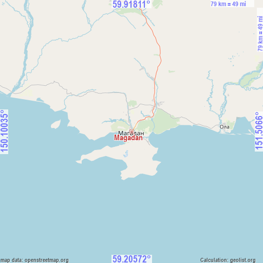
Magadan GPS coordinates[2]
59° 33' 49.68" North, 150° 48' 12.492" East
| Map corner | latitude | longitude |
|---|---|---|
| Upper-left | 59.91811°, | 150.10035° |
| Center: | 59.5638°, | 150.80347° |
| Lower-right: | 59.20572°, | 151.5066° |
| Map W x H: | 79.2×79.2 km | = 49.2×49.2mi |
| max Lat: | 73.50819° ⇑12% North |
| Magadan: | 59.5638° |
| min Lat: | ⇓88% South 41.28413° |
| min Long | Magadan | max Long |
| -179.12198° | 150.80347° | 179.35046° |
| W 99.2%⇐ | ⇒0.8% E |
Elevation
Elevation of Magadan is 65 m = 213 ft, and this is 137.6 m = 451 ft below average elevation for this country.
| Max E: |
2518 m = 8261 ft | 81.7% |
| Avg. | 202.6 m = 665 ft | |
| Magadan | 65 m = 213 ft | |
Min E: |
-28 m = -92 ft | 18.3% |
See also: Magadan elevation on elevation.city.
Geographical zone
Magadan is located in North temperate zone (between Tropic of Cancer and the Arctic Circle). Distance of this North polar circle is 778.3 km =483.6 mi to North.| Distance of | km | miles | from Magadan |
|---|---|---|---|
| North Pole | 3384.2 | 2102.8 | to North |
| Arctic Circle | 778.3 | 483.6 | to North |
| Tropic Cancer | 4017 | 2496 | to South |
| Equator | 6622.9 | 4115.3 | to South |


Nearby cities:
15 places around Magadan: (largest is in red/bold)
• Arman’
39.6 km =24.6 mi,  287°
287°
• Atka
151.5 km =94.1 mi,  21°
21°
• Burkhala
354.7 km =220.4 mi,  345°
345°
• Debin
308.9 km =191.9 mi,  359°
359°
• Karamken
73.6 km =45.7 mi,  12°
12°
• Ola
27.9 km =17.3 mi,  86°
86°
• Orotukan
303.9 km =188.8 mi, 8°
• Palatka
60.3 km =37.5 mi, 6°
• Sinegor'ye
281.1 km =174.7 mi, 356°
• Sokol
39.5 km =24.5 mi, 355°
• Spornoye
309.2 km =192.1 mi,  3°
3°
• Talaya
227.9 km =141.6 mi,  28°
28°
• Uptar
37.5 km =23.3 mi, 6°
• Ust’-Omchug
186 km =115.6 mi,  339°
339°
• Yagodnoye
335.2 km =208.3 mi, 349°
Sources, notices
• [Note1] Compared only with cities in Russia existing in our database
• [Src1] Map data: © OpenStreetMap contributors (CC-BY-SA)
• [Src2] Other city data from geonames.org with taken over terms of usage.
• [Src3] Geographical zone / Annual Mean Temperature by Robert A. Rohde @ Wikipedia
