Karamken geodata
Karamken (Magadan Oblast) is a populated place; located in Russia in Asia/Magadan (GMT+11) time zone. With population of 691 people, there are 4826 cities with bigger population in this country. Compared to other cities in Russia, 91.4% of cities are located further ↓South; 99.3% of cities are located further ←West and 91.5% of cities have lower elevation than Karamken. Note1


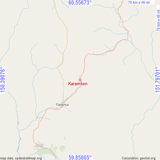
Karamken GPS coordinates[2]
60° 12' 33.3" North, 151° 5' 37.968" East
| Map corner | latitude | longitude |
|---|---|---|
| Upper-left | 60.55673°, | 150.39076° |
| Center: | 60.20925°, | 151.09388° |
| Lower-right: | 59.85805°, | 151.79701° |
| Map W x H: | 77.7×77.7 km | = 48.3×48.3mi |
| max Lat: | 73.50819° ⇑8.6% North |
| Karamken: | 60.20925° |
| min Lat: | ⇓91.4% South 41.28413° |
| min Long | Karamken | max Long |
| -179.12198° | 151.09388° | 179.35046° |
| W 99.3%⇐ | ⇒0.7% E |
Elevation
Elevation of Karamken is 491 m = 1611 ft, and this is 288.4 m = 946 ft above average elevation for this country.
| Max E: |
2518 m = 8261 ft | 8.5% |
| Karamken | 491 m 1611 ft | |
| Avg. | 202.6 m = 665 ft | |
Min E: |
-28 m = -92 ft | 91.5% |
See also: Russia elevation on elevation.city.
Geographical zone
Karamken is located in North temperate zone (between Tropic of Cancer and the Arctic Circle). Distance of this North polar circle is 706.5 km =439 mi to North.| Distance of | km | miles | from Karamken |
|---|---|---|---|
| North Pole | 3312.4 | 2058.2 | to North |
| Arctic Circle | 706.5 | 439 | to North |
| Tropic Cancer | 4088.7 | 2540.6 | to South |
| Equator | 6694.6 | 4159.8 | to South |


Nearby cities:
15 places around Karamken: (largest is in red/bold)
• Arman’
80.4 km =50 mi,  221°
221°
• Atka
79.3 km =49.3 mi,  28°
28°
• Burkhala
290.9 km =180.8 mi,  338°
338°
• Debin
237.8 km =147.8 mi,  355°
355°
• Magadan
73.6 km =45.7 mi,  192°
192°
• Ola
71.1 km =44.2 mi,  170°
170°
• Orotukan
230.6 km =143.3 mi,  7°
7°
• Palatka
14.9 km =9.3 mi, 216°
• Sinegor'ye
211.1 km =131.2 mi,  351°
351°
• Sokol
37.6 km =23.4 mi,  210°
210°
• Spornoye
237 km =147.3 mi,  0°
0°
• Talaya
157.9 km =98.1 mi,  35°
35°
• Uptar
36.6 km =22.7 mi,  199°
199°
• Ust’-Omchug
130 km =80.8 mi,  322°
322°
• Yagodnoye
269 km =167.1 mi, 343°
Sources, notices
• [Note1] Compared only with cities in Russia existing in our database
• [Src1] Map data: © OpenStreetMap contributors (CC-BY-SA)
• [Src2] Other city data from geonames.org with taken over terms of usage.
• [Src3] Geographical zone / Annual Mean Temperature by Robert A. Rohde @ Wikipedia
