Vorkuta geodata
Vorkuta (Komi) is a populated place; located in Russia in Europe/Moscow (GMT+3) time zone. With population of 80,039 people, there are 260 cities with bigger population in this country. Compared to other cities in Russia, 98.7% of cities are located further ↓South; 75.4% of cities are located further ←West and 65.4% of cities have lower elevation than Vorkuta. Note1


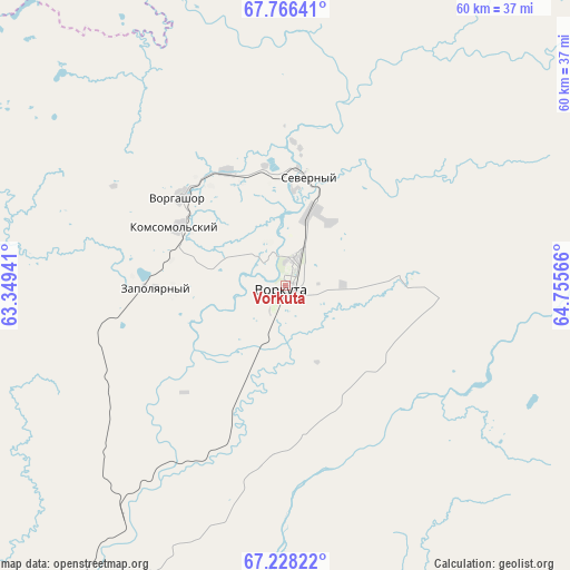
Vorkuta GPS coordinates[2]
67° 29' 55.824" North, 64° 3' 9.108" East
| Map corner | latitude | longitude |
|---|---|---|
| Upper-left | 67.76641°, | 63.34941° |
| Center: | 67.49884°, | 64.05253° |
| Lower-right: | 67.22822°, | 64.75566° |
| Map W x H: | 59.8×59.8 km | = 37.2×37.2mi |
| max Lat: | 73.50819° ⇑1.3% North |
| Vorkuta: | 67.49884° |
| min Lat: | ⇓98.7% South 41.28413° |
| min Long | Vorkuta | max Long |
| -179.12198° | 64.05253° | 179.35046° |
| W 75.4%⇐ | ⇒24.6% E |
Elevation
Elevation of Vorkuta is 183 m = 600 ft, and this is 19.6 m = 64 ft below average elevation for this country.
| Max E: |
2518 m = 8261 ft | 34.6% |
| Avg. | 202.6 m = 665 ft | |
| Vorkuta | 183 m = 600 ft | |
Min E: |
-28 m = -92 ft | 65.4% |
See also: Vorkuta elevation on elevation.city.
Geographical zone
Vorkuta is located in North Frigid zone (between North Pole and Arctic Circle). Distance of this North polar circle is 104 km =64.6 mi to South.| Distance of | km | miles | from Vorkuta |
|---|---|---|---|
| North Pole | 2501.9 | 1554.6 | to North |
| Arctic Circle | 104 | 64.6 | to South |
| Tropic Cancer | 4899.2 | 3044.2 | to South |
| Equator | 7505.2 | 4663.5 | to South |


Nearby cities:
14 places around Vorkuta: (largest is in red/bold)
• Aksarka
193.1 km =120 mi,  122°
122°
• Amderma
269.1 km =167.2 mi,  338°
338°
• Berëzovo
398.5 km =247.6 mi,  173°
173°
• Kharp
108.4 km =67.4 mi,  135°
135°
• Laborovaya
149.3 km =92.8 mi,  83°
83°
• Labytnangi
138.7 km =86.2 mi,  132°
132°
• Muzhi
235.1 km =146.1 mi, 172°
• Promyshlennyy
11 km =6.8 mi,  328°
328°
• Salekhard
154.4 km =95.9 mi, 134°
• Sovetskiy
15.6 km =9.7 mi,  96°
96°
• Tsementnozavodskiy
14.5 km =9 mi,  6°
6°
• Vorgashor
14.5 km =9 mi,  310°
310°
• Yeletskiy
50.8 km =31.6 mi, 172°
• Zapolyarnyy
13.6 km =8.5 mi,  268°
268°
In other languages:
- In Spanish: Vorkutá
- In France: Vorkouta
- In German: Workuta
- In Russian: Воркута
- In Chinese: 沃尔库塔
Sources, notices
• [Note1] Compared only with cities in Russia existing in our database
• [Src1] Map data: © OpenStreetMap contributors (CC-BY-SA)
• [Src2] Other city data from geonames.org with taken over terms of usage.
• [Src3] Geographical zone / Annual Mean Temperature by Robert A. Rohde @ Wikipedia
