Salekhard geodata
Salekhard (Yamalo-Nenets) is a seat of a first-order administrative division; located in Russia in Asia/Yekaterinburg (GMT+5) time zone. With population of 38,025 people, there are 548 cities with bigger population in this country. Compared to other cities in Russia, 98.3% of cities are located further ↓South; 76.5% of cities are located further ←West and 90.7% of cities have higher elevation than Salekhard. Note1


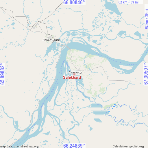
Salekhard GPS coordinates[2]
66° 31' 48" North, 66° 36' 6.984" East
| Map corner | latitude | longitude |
|---|---|---|
| Upper-left | 66.80846°, | 65.89882° |
| Center: | 66.53°, | 66.60194° |
| Lower-right: | 66.24839°, | 67.30507° |
| Map W x H: | 62.3×62.3 km | = 38.7×38.7mi |
| max Lat: | 73.50819° ⇑1.7% North |
| Salekhard: | 66.53° |
| min Lat: | ⇓98.3% South 41.28413° |
| min Long | Salekhard | max Long |
| -179.12198° | 66.60194° | 179.35046° |
| W 76.5%⇐ | ⇒23.5% E |
Elevation
Elevation of Salekhard is 26 m = 85 ft, and this is 176.6 m = 579 ft below average elevation for this country.
| Max E: |
2518 m = 8261 ft | 90.7% |
| Avg. | 202.6 m = 665 ft | |
| Salekhard | 26 m = 85 ft | |
Min E: |
-28 m = -92 ft | 9.3% |
See also: Russia elevation on elevation.city.
Geographical zone
Salekhard is located in North temperate zone (between Tropic of Cancer and the Arctic Circle). Distance of this North polar circle is 3.7 km =2.3 mi to North.| Distance of | km | miles | from Salekhard |
|---|---|---|---|
| North Pole | 2609.6 | 1621.5 | to North |
| Arctic Circle | 3.7 | 2.3 | to North |
| Tropic Cancer | 4791.5 | 2977.3 | to South |
| Equator | 7397.4 | 4596.5 | to South |


Nearby cities:
15 places around Salekhard: (largest is in red/bold)
• Aksarka
53 km =32.9 mi,  86°
86°
• Beloyarskiy
313.4 km =194.7 mi,  179°
179°
• Berëzovo
297.2 km =184.7 mi,  194°
194°
• Kharp
46.2 km =28.7 mi,  310°
310°
• Kutop’yugan
169.5 km =105.3 mi,  97°
97°
• Laborovaya
130.1 km =80.8 mi,  18°
18°
• Labytnangi
16.3 km =10.1 mi,  330°
330°
• Muzhi
152.2 km =94.6 mi,  214°
214°
• Promyshlennyy
165.1 km =102.6 mi,  315°
315°
• Sovetskiy
142.3 km =88.4 mi, 318°
• Tsementnozavodskiy
163.5 km =101.6 mi, 318°
• Vorgashor
168.9 km =104.9 mi, 313°
• Vorkuta
154.4 km =95.9 mi, 314°
• Yeletskiy
119.3 km =74.1 mi,  298°
298°
• Zapolyarnyy
164.4 km =102.2 mi, 310°
In other languages:
- In Spanish: Salejard
- In German: Salechard
- In Italian: Salechard
- In Russian: Салехард
- In Chinese: 萨列哈尔德
Sources, notices
• [Note1] Compared only with cities in Russia existing in our database
• [Src1] Map data: © OpenStreetMap contributors (CC-BY-SA)
• [Src2] Other city data from geonames.org with taken over terms of usage.
• [Src3] Geographical zone / Annual Mean Temperature by Robert A. Rohde @ Wikipedia
