Tsementnozavodskiy geodata
Tsementnozavodskiy (Komi) is a populated place; located in Russia in Europe/Moscow (GMT+3) time zone. With population of 2,135 people, there are 4101 cities with bigger population in this country. Compared to other cities in Russia, 98.9% of cities are located further ↓South; 75.4% of cities are located further ←West and 63.6% of cities have lower elevation than Tsementnozavodskiy. Note1


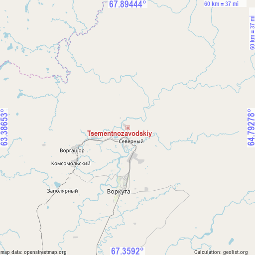
Tsementnozavodskiy GPS coordinates[2]
67° 37' 42.024" North, 64° 5' 22.74" East
| Map corner | latitude | longitude |
|---|---|---|
| Upper-left | 67.89444°, | 63.38653° |
| Center: | 67.62834°, | 64.08965° |
| Lower-right: | 67.3592°, | 64.79278° |
| Map W x H: | 59.5×59.5 km | = 37×37mi |
| max Lat: | 73.50819° ⇑1.1% North |
| Tsementnozavodskiy: | 67.62834° |
| min Lat: | ⇓98.9% South 41.28413° |
| min Long | Tsementnozavods | max Long |
| -179.12198° | 64.08965° | 179.35046° |
| W 75.4%⇐ | ⇒24.6% E |
Elevation
Elevation of Tsementnozavodskiy is 178 m = 584 ft, and this is 24.6 m = 81 ft below average elevation for this country.
| Max E: |
2518 m = 8261 ft | 36.4% |
| Avg. | 202.6 m = 665 ft | |
| Tsementnozavodskiy | 178 m = 584 ft | |
Min E: |
-28 m = -92 ft | 63.6% |
See also: Russia elevation on elevation.city.
Geographical zone
Tsementnozavodskiy is located in North Frigid zone (between North Pole and Arctic Circle). Distance of this North polar circle is 118.4 km =73.6 mi to South.| Distance of | km | miles | from Tsementnozavodskiy |
|---|---|---|---|
| North Pole | 2487.5 | 1545.7 | to North |
| Arctic Circle | 118.4 | 73.6 | to South |
| Tropic Cancer | 4913.6 | 3053.2 | to South |
| Equator | 7519.6 | 4672.5 | to South |


Nearby cities:
14 places around Tsementnozavodskiy: (largest is in red/bold)
• Aksarka
199.6 km =124 mi,  126°
126°
• Amderma
256.2 km =159.2 mi,  337°
337°
• Berëzovo
412.6 km =256.4 mi,  173°
173°
• Kharp
118 km =73.3 mi,  141°
141°
• Laborovaya
146.5 km =91 mi,  89°
89°
• Labytnangi
147.5 km =91.7 mi, 137°
• Muzhi
249.2 km =154.8 mi, 173°
• Promyshlennyy
8.9 km =5.5 mi,  235°
235°
• Salekhard
163.5 km =101.6 mi, 138°
• Sovetskiy
21.3 km =13.2 mi, 139°
• Vorgashor
13.5 km =8.4 mi,  248°
248°
• Vorkuta
14.5 km =9 mi,  186°
186°
• Yeletskiy
65 km =40.4 mi,  175°
175°
• Zapolyarnyy
21.2 km =13.2 mi,  225°
225°
Sources, notices
• [Note1] Compared only with cities in Russia existing in our database
• [Src1] Map data: © OpenStreetMap contributors (CC-BY-SA)
• [Src2] Other city data from geonames.org with taken over terms of usage.
• [Src3] Geographical zone / Annual Mean Temperature by Robert A. Rohde @ Wikipedia
