Sovetskiy geodata
Sovetskiy (Komi) is a populated place; located in Russia in Europe/Moscow (GMT+3) time zone. With population of 2,415 people, there are 3988 cities with bigger population in this country. Compared to other cities in Russia, 98.7% of cities are located further ↓South; 75.5% of cities are located further ←West and 63.8% of cities have lower elevation than Sovetskiy. Note1


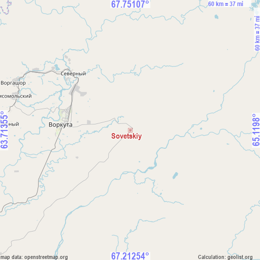
Sovetskiy GPS coordinates[2]
67° 28' 59.988" North, 64° 25' 0.012" East
| Map corner | latitude | longitude |
|---|---|---|
| Upper-left | 67.75107°, | 63.71355° |
| Center: | 67.48333°, | 64.41667° |
| Lower-right: | 67.21254°, | 65.1198° |
| Map W x H: | 59.9×59.9 km | = 37.2×37.2mi |
| max Lat: | 73.50819° ⇑1.3% North |
| Sovetskiy: | 67.48333° |
| min Lat: | ⇓98.7% South 41.28413° |
| min Long | Sovetskiy | max Long |
| -179.12198° | 64.41667° | 179.35046° |
| W 75.5%⇐ | ⇒24.5% E |
Elevation
Elevation of Sovetskiy is 179 m = 587 ft, and this is 23.6 m = 77 ft below average elevation for this country.
| Max E: |
2518 m = 8261 ft | 36.2% |
| Avg. | 202.6 m = 665 ft | |
| Sovetskiy | 179 m = 587 ft | |
Min E: |
-28 m = -92 ft | 63.8% |
See also: Russia elevation on elevation.city.
Geographical zone
Sovetskiy is located in North Frigid zone (between North Pole and Arctic Circle). Distance of this North polar circle is 102.3 km =63.6 mi to South.| Distance of | km | miles | from Sovetskiy |
|---|---|---|---|
| North Pole | 2503.6 | 1555.7 | to North |
| Arctic Circle | 102.3 | 63.6 | to South |
| Tropic Cancer | 4897.5 | 3043.2 | to South |
| Equator | 7503.4 | 4662.4 | to South |


Nearby cities:
14 places around Sovetskiy: (largest is in red/bold)
• Aksarka
179 km =111.2 mi,  124°
124°
• Amderma
276.3 km =171.7 mi,  336°
336°
• Berëzovo
395.2 km =245.6 mi,  175°
175°
• Kharp
96.7 km =60.1 mi,  141°
141°
• Laborovaya
134.2 km =83.4 mi,  82°
82°
• Labytnangi
126.3 km =78.5 mi, 136°
• Muzhi
232 km =144.2 mi, 176°
• Promyshlennyy
24 km =14.9 mi,  297°
297°
• Salekhard
142.3 km =88.4 mi, 138°
• Tsementnozavodskiy
21.3 km =13.2 mi,  319°
319°
• Vorgashor
28.7 km =17.8 mi,  292°
292°
• Vorkuta
15.6 km =9.7 mi,  276°
276°
• Yeletskiy
49.4 km =30.7 mi,  190°
190°
• Zapolyarnyy
29.1 km =18.1 mi,  272°
272°
Sources, notices
• [Note1] Compared only with cities in Russia existing in our database
• [Src1] Map data: © OpenStreetMap contributors (CC-BY-SA)
• [Src2] Other city data from geonames.org with taken over terms of usage.
• [Src3] Geographical zone / Annual Mean Temperature by Robert A. Rohde @ Wikipedia
