Labytnangi geodata
Labytnangi (Yamalo-Nenets) is a populated place; located in Russia in Asia/Yekaterinburg (GMT+5) time zone. With population of 27,067 people, there are 718 cities with bigger population in this country. Compared to other cities in Russia, 98.3% of cities are located further ↓South; 76.4% of cities are located further ←West and 98.8% of cities have higher elevation than Labytnangi. Note1


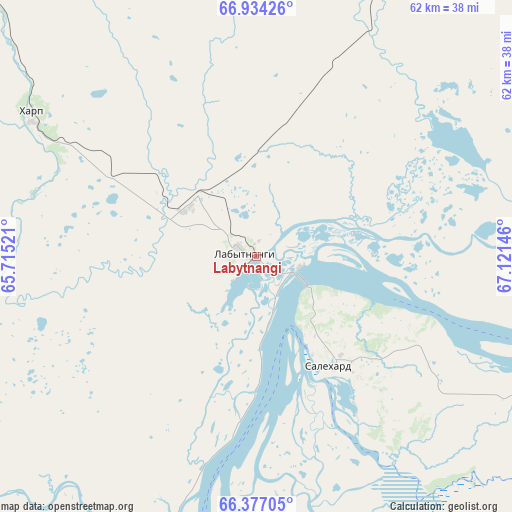
Labytnangi GPS coordinates[2]
66° 39' 25.992" North, 66° 25' 5.988" East
| Map corner | latitude | longitude |
|---|---|---|
| Upper-left | 66.93426°, | 65.71521° |
| Center: | 66.65722°, | 66.41833° |
| Lower-right: | 66.37705°, | 67.12146° |
| Map W x H: | 62×62 km | = 38.5×38.5mi |
| max Lat: | 73.50819° ⇑1.7% North |
| Labytnangi: | 66.65722° |
| min Lat: | ⇓98.3% South 41.28413° |
| min Long | Labytnangi | max Long |
| -179.12198° | 66.41833° | 179.35046° |
| W 76.4%⇐ | ⇒23.6% E |
Elevation
Elevation of Labytnangi is 1 m = 3 ft, and this is 201.6 m = 661 ft below average elevation for this country.
| Max E: |
2518 m = 8261 ft | 98.8% |
| Avg. | 202.6 m = 665 ft | |
| Labytnangi | 1 m = 3 ft | |
Min E: |
-28 m = -92 ft | 1.2% |
See also: Russia elevation on elevation.city.
Geographical zone
Labytnangi is located in North Frigid zone (between North Pole and Arctic Circle). Distance of this North polar circle is 10.4 km =6.5 mi to South.| Distance of | km | miles | from Labytnangi |
|---|---|---|---|
| North Pole | 2595.5 | 1612.8 | to North |
| Arctic Circle | 10.4 | 6.5 | to South |
| Tropic Cancer | 4805.7 | 2986.1 | to South |
| Equator | 7411.6 | 4605.4 | to South |


Nearby cities:
15 places around Labytnangi: (largest is in red/bold)
• Aksarka
61.8 km =38.4 mi,  100°
100°
• Beloyarskiy
327.7 km =203.6 mi,  177°
177°
• Berëzovo
309 km =192 mi,  191°
191°
• Kharp
31.2 km =19.4 mi,  300°
300°
• Kutop’yugan
179.4 km =111.5 mi, 101°
• Laborovaya
119.8 km =74.4 mi,  24°
24°
• Muzhi
159.8 km =99.3 mi,  209°
209°
• Promyshlennyy
149.3 km =92.8 mi,  313°
313°
• Salekhard
16.3 km =10.1 mi,  150°
150°
• Sovetskiy
126.3 km =78.5 mi,  316°
316°
• Tsementnozavodskiy
147.5 km =91.7 mi, 317°
• Vorgashor
153.2 km =95.2 mi, 312°
• Vorkuta
138.7 km =86.2 mi, 312°
• Yeletskiy
105.6 km =65.6 mi,  294°
294°
• Zapolyarnyy
149 km =92.6 mi, 308°
In other languages:
- In Spanish: Labytnangui
- In France: Labytnangui
- In Russian: Лабытнанги
- In Chinese: 拉貝特南吉
Sources, notices
• [Note1] Compared only with cities in Russia existing in our database
• [Src1] Map data: © OpenStreetMap contributors (CC-BY-SA)
• [Src2] Other city data from geonames.org with taken over terms of usage.
• [Src3] Geographical zone / Annual Mean Temperature by Robert A. Rohde @ Wikipedia
