Loma geodata
Loma (Northern Province) is a populated place; located in Sierra Leone in Africa/Freetown (GMT+0) time zone. With population of 3,435 people, there are 67 cities with bigger population in this country. Compared to other cities in Sierra Leone, 97.6% of cities are located further ↓South; 67.5% of cities are located further →East and 59% of cities have lower elevation than Loma. Note1


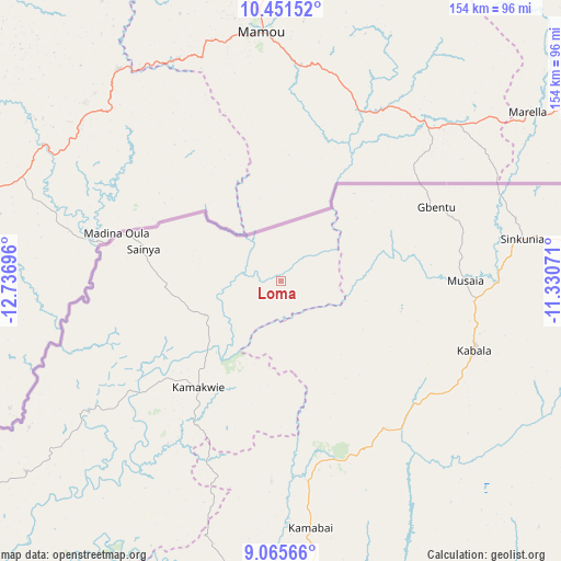
Loma GPS coordinates[2]
9° 45' 33.516" North, 12° 2' 1.788" West
| Map corner | latitude | longitude |
|---|---|---|
| Upper-left | 10.45152°, | -12.73696° |
| Center: | 9.75931°, | -12.03383° |
| Lower-right: | 9.06566°, | -11.33071° |
| Map W x H: | 154.1×154.1 km | = 95.8×95.8mi |
| max Lat: | 9.91376° ⇑2.4% North |
| Loma: | 9.75931° |
| min Lat: | ⇓97.6% South 7.24611° |
| min Long | Loma | max Long |
| -13.28972° | -12.03383° | -10.37135° |
| W 32.5%⇐ | ⇒67.5% E |
Elevation
Elevation of Loma is 139 m = 456 ft, and this is 18.2 m = 60 ft below average elevation for this country.
| Max E: |
564 m = 1850 ft | 41% |
| Avg. | 157.2 m = 516 ft | |
| Loma | 139 m = 456 ft | |
Min E: |
1 m = 3 ft | 59% |
See also: Sierra Leone elevation on elevation.city.
Geographical zone
Loma is located in North Torrid zone (between Equator and Tropic of Cancer). Distance of Equator is 1085.1 km =674.2 mi to South.| Distance of | km | miles | from Loma |
|---|---|---|---|
| North Pole | 8921.9 | 5543.8 | to North |
| Arctic Circle | 6316 | 3924.6 | to North |
| Tropic Cancer | 1520.8 | 945 | to North |
| Equator | 1085.1 | 674.2 | to South |


Nearby cities:
15 places around Loma: (largest is in red/bold)
• Alikalia
97.8 km =60.8 mi,  133°
133°
• Bindi
66.6 km =41.4 mi,  75°
75°
• Binkolo
89.9 km =55.9 mi,  176°
176°
• Bumbuna
85.5 km =53.1 mi,  158°
158°
• Gberia Fotombu
96.1 km =59.7 mi, 82°
• Kabala
56 km =34.8 mi,  109°
109°
• Kamakwie
36.9 km =22.9 mi,  217°
217°
• Kambia
119.9 km =74.5 mi,  233°
233°
• Kukuna
80 km =49.7 mi,  239°
239°
• Magburaka
115.6 km =71.8 mi, 175°
• Makeni
97.1 km =60.3 mi, 180°
• Mange
129.6 km =80.5 mi, 224°
• Masaka
124.3 km =77.2 mi,  168°
168°
• Masingbi
109 km =67.7 mi, 175°
• Rokupr
127 km =78.9 mi,  197°
197°
Sources, notices
• [Note1] Compared only with cities in Sierra Leone existing in our database
• [Src1] Map data: © OpenStreetMap contributors (CC-BY-SA)
• [Src2] Other city data from geonames.org with taken over terms of usage.
• [Src3] Geographical zone / Annual Mean Temperature by Robert A. Rohde @ Wikipedia
