Kabala geodata
Kabala (Northern Province) is a populated place; located in Sierra Leone in Africa/Freetown (GMT+0) time zone. With population of 17,948 people, there are 8 cities with bigger population in this country. Compared to other cities in Sierra Leone, 96.4% of cities are located further ↓South; 55.4% of cities are located further ←West and 97.6% of cities have lower elevation than Kabala. Note1


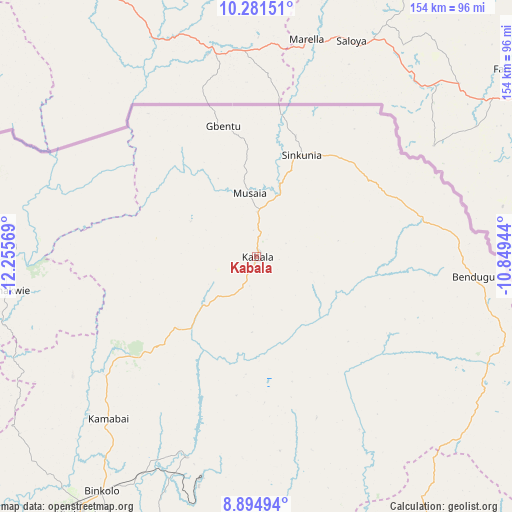
Kabala GPS coordinates[2]
9° 35' 20.148" North, 11° 33' 9.216" West
| Map corner | latitude | longitude |
|---|---|---|
| Upper-left | 10.28151°, | -12.25569° |
| Center: | 9.58893°, | -11.55256° |
| Lower-right: | 8.89494°, | -10.84944° |
| Map W x H: | 154.2×154.2 km | = 95.8×95.8mi |
| max Lat: | 9.91376° ⇑3.6% North |
| Kabala: | 9.58893° |
| min Lat: | ⇓96.4% South 7.24611° |
| min Long | Kabala | max Long |
| -13.28972° | -11.55256° | -10.37135° |
| W 55.4%⇐ | ⇒44.6% E |
Elevation
Elevation of Kabala is 433 m = 1421 ft, and this is 275.8 m = 905 ft above average elevation for this country.
| Max E: |
564 m = 1850 ft | 2.4% |
| Kabala | 433 m 1421 ft | |
| Avg. | 157.2 m = 516 ft | |
Min E: |
1 m = 3 ft | 97.6% |
See also: Sierra Leone elevation on elevation.city.
Geographical zone
Kabala is located in North Torrid zone (between Equator and Tropic of Cancer). Distance of Equator is 1066.2 km =662.5 mi to South.| Distance of | km | miles | from Kabala |
|---|---|---|---|
| North Pole | 8940.9 | 5555.6 | to North |
| Arctic Circle | 6335 | 3936.4 | to North |
| Tropic Cancer | 1539.7 | 956.7 | to North |
| Equator | 1066.2 | 662.5 | to South |


Nearby cities:
15 places around Kabala: (largest is in red/bold)
• Alikalia
51.7 km =32.1 mi,  159°
159°
• Bindi
37.9 km =23.5 mi,  17°
17°
• Binkolo
84.9 km =52.8 mi,  213°
213°
• Bumbuna
64.1 km =39.8 mi,  199°
199°
• Gberia Fotombu
53.3 km =33.1 mi,  52°
52°
• Kamakwie
76.1 km =47.3 mi,  262°
262°
• Kayima
89.1 km =55.4 mi,  151°
151°
• Loma
56 km =34.8 mi,  289°
289°
• Magburaka
105.6 km =65.6 mi, 204°
• Makali
107.3 km =66.7 mi,  186°
186°
• Makeni
95 km =59 mi, 214°
• Masaka
106.3 km =66.1 mi, 194°
• Masingbi
99.9 km =62.1 mi, 206°
• Tefeya
105.2 km =65.4 mi, 159°
• Yengema
105.9 km =65.8 mi, 156°
Sources, notices
• [Note1] Compared only with cities in Sierra Leone existing in our database
• [Src1] Map data: © OpenStreetMap contributors (CC-BY-SA)
• [Src2] Other city data from geonames.org with taken over terms of usage.
• [Src3] Geographical zone / Annual Mean Temperature by Robert A. Rohde @ Wikipedia
