Gberia Fotombu geodata
Gberia Fotombu (Northern Province) is a populated place; located in Sierra Leone in Africa/Freetown (GMT+0) time zone. With population of 3,034 people, there are 76 cities with bigger population in this country. Compared to other cities in Sierra Leone, 98.8% of cities are located further ↓South; 74.7% of cities are located further ←West and 98.8% of cities have lower elevation than Gberia Fotombu. Note1


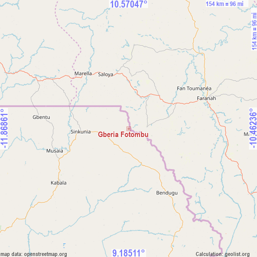
Gberia Fotombu GPS coordinates[2]
9° 52' 42.672" North, 11° 9' 55.728" West
| Map corner | latitude | longitude |
|---|---|---|
| Upper-left | 10.57047°, | -11.86861° |
| Center: | 9.87852°, | -11.16548° |
| Lower-right: | 9.18511°, | -10.46236° |
| Map W x H: | 154×154 km | = 95.7×95.7mi |
| max Lat: | 9.91376° ⇑1.2% North |
| Gberia Fotombu: | 9.87852° |
| min Lat: | ⇓98.8% South 7.24611° |
| min Long | Gberia Fotombu | max Long |
| -13.28972° | -11.16548° | -10.37135° |
| W 74.7%⇐ | ⇒25.3% E |
Elevation
Elevation of Gberia Fotombu is 483 m = 1585 ft, and this is 325.8 m = 1069 ft above average elevation for this country.
| Max E: |
564 m = 1850 ft | 1.2% |
| Gberia Fotombu | 483 m 1585 ft | |
| Avg. | 157.2 m = 516 ft | |
Min E: |
1 m = 3 ft | 98.8% |
See also: Sierra Leone elevation on elevation.city.
Geographical zone
Gberia Fotombu is located in North Torrid zone (between Equator and Tropic of Cancer). Distance of Equator is 1098.4 km =682.5 mi to South.| Distance of | km | miles | from Gberia Fotombu |
|---|---|---|---|
| North Pole | 8908.7 | 5535.6 | to North |
| Arctic Circle | 6302.8 | 3916.4 | to North |
| Tropic Cancer | 1507.5 | 936.7 | to North |
| Equator | 1098.4 | 682.5 | to South |


Nearby cities:
15 places around Gberia Fotombu: (largest is in red/bold)
• Alikalia
84.2 km =52.3 mi,  196°
196°
• Bindi
31.1 km =19.3 mi,  277°
277°
• Binkolo
136.4 km =84.8 mi,  220°
220°
• Bumbuna
112.5 km =69.9 mi,  214°
214°
• Kabala
53.3 km =33.1 mi,  232°
232°
• Kamakwie
125.2 km =77.8 mi,  250°
250°
• Kayima
110.1 km =68.4 mi,  179°
179°
• Koidu
138.9 km =86.3 mi,  171°
171°
• Koyima
131.4 km =81.6 mi, 173°
• Loma
96.1 km =59.7 mi,  262°
262°
• Motema
141.6 km =88 mi, 173°
• Seidu
114.3 km =71 mi,  146°
146°
• Simbakoro
141.8 km =88.1 mi, 172°
• Tefeya
130.7 km =81.2 mi, 182°
• Yengema
129.4 km =80.4 mi, 180°
Sources, notices
• [Note1] Compared only with cities in Sierra Leone existing in our database
• [Src1] Map data: © OpenStreetMap contributors (CC-BY-SA)
• [Src2] Other city data from geonames.org with taken over terms of usage.
• [Src3] Geographical zone / Annual Mean Temperature by Robert A. Rohde @ Wikipedia
