Tambacounda geodata
Tambacounda is a seat of a first-order administrative division; located in Senegal in Africa/Dakar (GMT+0) time zone. With population of 78,800 people, there are 9 cities with bigger population in this country. Compared to other cities in Senegal, 81.7% of cities are located further ↑North; 86.7% of cities are located further ←West and 75% of cities have lower elevation than Tambacounda. Note1


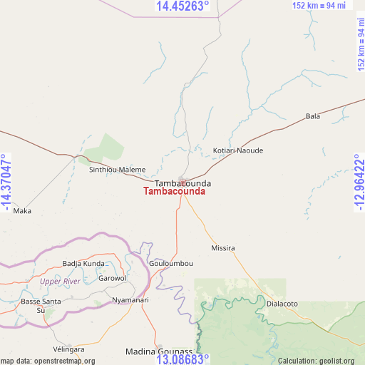
Tambacounda GPS coordinates[2]
13° 46' 14.628" North, 13° 40' 2.424" West
| Map corner | latitude | longitude |
|---|---|---|
| Upper-left | 14.45263°, | -14.37047° |
| Center: | 13.77073°, | -13.66734° |
| Lower-right: | 13.08683°, | -12.96422° |
| Map W x H: | 151.9×151.9 km | = 94.4×94.4mi |
| max Lat: | 16.51293° ⇑81.7% North |
| Tambacounda: | 13.77073° |
| min Lat: | ⇓18.3% South 12.485° |
| min Long | Tambacounda | max Long |
| -17.47581° | -13.66734° | -12.18076° |
| W 86.7%⇐ | ⇒13.3% E |
Elevation
Elevation of Tambacounda is 32 m = 105 ft, and this is 7.5 m = 25 ft above average elevation for this country.
| Max E: |
127 m = 417 ft | 25% |
| Tambacounda | 32 m 105 ft | |
| Avg. | 24.5 m = 80 ft | |
Min E: |
0 m = 0 ft | 75% |
See also: Tambacounda elevation on elevation.city.
Geographical zone
Tambacounda is located in North Torrid zone (between Equator and Tropic of Cancer). Distance of this Northern Tropic circle is 1074.8 km =667.8 mi to North.| Distance of | km | miles | from Tambacounda |
|---|---|---|---|
| North Pole | 8475.9 | 5266.7 | to North |
| Arctic Circle | 5870 | 3647.4 | to North |
| Tropic Cancer | 1074.8 | 667.8 | to North |
| Equator | 1531.2 | 951.4 | to South |


Nearby cities:
15 places around Tambacounda: (largest is in red/bold)
• Diawara
184.4 km =114.6 mi,  41°
41°
• Kaffrine
206.6 km =128.4 mi,  280°
280°
• Kanel
198.5 km =123.3 mi,  15°
15°
• Kolda
168.8 km =104.9 mi,  234°
234°
• Koungheul
124.5 km =77.4 mi, 280°
• Kédougou
210.1 km =130.6 mi,  130°
130°
• Matam
214.2 km =133.1 mi,  11°
11°
• Nioro du Rip
230.3 km =143.1 mi,  269°
269°
• Ouro Sogui
207.4 km =128.9 mi, 10°
• Polel Diaoubé
181.2 km =112.6 mi, 23°
• Ranérou
173.1 km =107.6 mi,  349°
349°
• Sédhiou
236.2 km =146.8 mi,  239°
239°
• Sémé
176.4 km =109.6 mi,  26°
26°
• Vélingara
84.4 km =52.4 mi,  215°
215°
• Waoundé
187 km =116.2 mi, 27°
Sources, notices
• [Note1] Compared only with cities in Senegal existing in our database
• [Src1] Map data: © OpenStreetMap contributors (CC-BY-SA)
• [Src2] Other city data from geonames.org with taken over terms of usage.
• [Src3] Geographical zone / Annual Mean Temperature by Robert A. Rohde @ Wikipedia
