Taboshar geodata
Taboshar (Sughd) is a populated place; located in Tajikistan in Asia/Dushanbe (GMT+5) time zone. With population of 11,578 people, there are 31 cities with bigger population in this country. Compared to other cities in Tajikistan, 94.3% of cities are located further ↓South; 58% of cities are located further ←West and 64.8% of cities have lower elevation than Taboshar. Note1


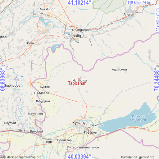
Taboshar GPS coordinates[2]
40° 34' 12.612" North, 69° 38' 30.3" East
| Map corner | latitude | longitude |
|---|---|---|
| Upper-left | 41.10214°, | 68.93863° |
| Center: | 40.57017°, | 69.64175° |
| Lower-right: | 40.03394°, | 70.34488° |
| Map W x H: | 118.8×118.8 km | = 73.8×73.8mi |
| max Lat: | 40.99827° ⇑5.7% North |
| Taboshar: | 40.57017° |
| min Lat: | ⇓94.3% South 36.72484° |
| min Long | Taboshar | max Long |
| 67.60931° | 69.64175° | 73.96674° |
| W 58%⇐ | ⇒42% E |
Elevation
Elevation of Taboshar is 1196 m = 3924 ft, and this is 233.5 m = 766 ft above average elevation for this country.
| Max E: |
3607 m = 11834 ft | 35.2% |
| Taboshar | 1196 m 3924 ft | |
| Avg. | 962.5 m = 3158 ft | |
Min E: |
324 m = 1063 ft | 64.8% |
See also: Tajikistan elevation on elevation.city.
Geographical zone
Taboshar is located in North temperate zone (between Tropic of Cancer and the Arctic Circle). Distance of this Northern Tropic circle is 1905.1 km =1183.8 mi to South.| Distance of | km | miles | from Taboshar |
|---|---|---|---|
| North Pole | 5496.1 | 3415.1 | to North |
| Arctic Circle | 2890.2 | 1795.9 | to North |
| Tropic Cancer | 1905.1 | 1183.8 | to South |
| Equator | 4511 | 2803 | to South |


Nearby cities:
15 places around Taboshar: (largest is in red/bold)
• Adrasmon
30.3 km =18.8 mi,  73°
73°
• Bŭston
26.6 km =16.5 mi,  258°
258°
• Chkalov
37.6 km =23.4 mi,  173°
173°
• Ghafurov
40.1 km =24.9 mi, 169°
• Ghonchí
80.3 km =49.9 mi,  212°
212°
• Khŭjand
32 km =19.9 mi,  182°
182°
• Konibodom
73.5 km =45.7 mi,  114°
114°
• Konsoy
10.1 km =6.3 mi,  149°
149°
• Nov
51.8 km =32.2 mi, 206°
• Oltintopkan
10 km =6.2 mi,  338°
338°
• Palos
29.4 km =18.3 mi,  163°
163°
• Proletar
46.4 km =28.8 mi,  194°
194°
• Quruqsoy
22.1 km =13.7 mi,  271°
271°
• Shaydon
60.8 km =37.8 mi,  79°
79°
• Zafarobod
80.3 km =49.9 mi,  236°
236°
Sources, notices
• [Note1] Compared only with cities in Tajikistan existing in our database
• [Src1] Map data: © OpenStreetMap contributors (CC-BY-SA)
• [Src2] Other city data from geonames.org with taken over terms of usage.
• [Src3] Geographical zone / Annual Mean Temperature by Robert A. Rohde @ Wikipedia
