Oltintopkan geodata
Oltintopkan (Sughd) is a populated place; located in Tajikistan in Asia/Dushanbe (GMT+5) time zone. With population of 4,823 people, there are 49 cities with bigger population in this country. Compared to other cities in Tajikistan, 97.7% of cities are located further ↓South; 54.5% of cities are located further ←West and 72.7% of cities have lower elevation than Oltintopkan. Note1


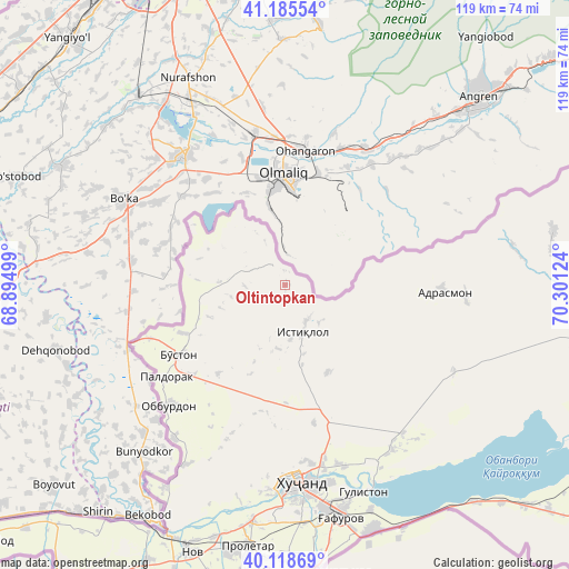
Oltintopkan GPS coordinates[2]
40° 39' 15.3" North, 69° 35' 53.196" East
| Map corner | latitude | longitude |
|---|---|---|
| Upper-left | 41.18554°, | 68.89499° |
| Center: | 40.65425°, | 69.59811° |
| Lower-right: | 40.11869°, | 70.30124° |
| Map W x H: | 118.6×118.6 km | = 73.7×73.7mi |
| max Lat: | 40.99827° ⇑2.3% North |
| Oltintopkan: | 40.65425° |
| min Lat: | ⇓97.7% South 36.72484° |
| min Long | Oltintopkan | max Long |
| 67.60931° | 69.59811° | 73.96674° |
| W 54.5%⇐ | ⇒45.5% E |
Elevation
Elevation of Oltintopkan is 1259 m = 4131 ft, and this is 296.5 m = 973 ft above average elevation for this country.
| Max E: |
3607 m = 11834 ft | 27.3% |
| Oltintopkan | 1259 m 4131 ft | |
| Avg. | 962.5 m = 3158 ft | |
Min E: |
324 m = 1063 ft | 72.7% |
See also: Tajikistan elevation on elevation.city.
Geographical zone
Oltintopkan is located in North temperate zone (between Tropic of Cancer and the Arctic Circle). Distance of this Northern Tropic circle is 1914.4 km =1189.6 mi to South.| Distance of | km | miles | from Oltintopkan |
|---|---|---|---|
| North Pole | 5486.7 | 3409.3 | to North |
| Arctic Circle | 2880.8 | 1790 | to North |
| Tropic Cancer | 1914.4 | 1189.6 | to South |
| Equator | 4520.3 | 2808.8 | to South |


Nearby cities:
15 places around Oltintopkan: (largest is in red/bold)
• Adrasmon
32.6 km =20.3 mi,  90°
90°
• Bŭston
26.7 km =16.6 mi,  236°
236°
• Chkalov
47.4 km =29.5 mi,  170°
170°
• Ghafurov
50 km =31.1 mi, 167°
• Khŭjand
41.4 km =25.7 mi,  177°
177°
• Konibodom
81 km =50.3 mi,  119°
119°
• Konsoy
20.1 km =12.5 mi,  154°
154°
• Navgarzan
79.6 km =49.5 mi,  61°
61°
• Nov
59 km =36.7 mi,  199°
199°
• Palos
39.4 km =24.5 mi,  162°
162°
• Proletar
54.8 km =34.1 mi,  188°
188°
• Quruqsoy
20.4 km =12.7 mi, 244°
• Shaydon
63.5 km =39.5 mi, 88°
• Taboshar
10 km =6.2 mi, 158°
• Zafarobod
82.9 km =51.5 mi,  230°
230°
Sources, notices
• [Note1] Compared only with cities in Tajikistan existing in our database
• [Src1] Map data: © OpenStreetMap contributors (CC-BY-SA)
• [Src2] Other city data from geonames.org with taken over terms of usage.
• [Src3] Geographical zone / Annual Mean Temperature by Robert A. Rohde @ Wikipedia
