Adrasmon geodata
Adrasmon (Sughd) is a populated place; located in Tajikistan in Asia/Dushanbe (GMT+5) time zone. With population of 13,372 people, there are 26 cities with bigger population in this country. Compared to other cities in Tajikistan, 96.6% of cities are located further ↓South; 73.9% of cities are located further ←West and 86.4% of cities have lower elevation than Adrasmon. Note1


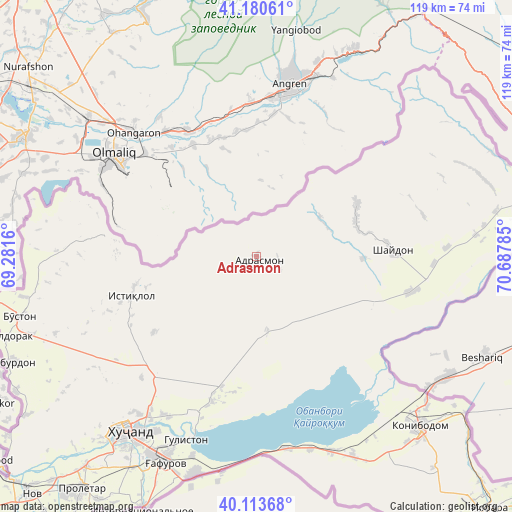
Adrasmon GPS coordinates[2]
40° 38' 57.408" North, 69° 59' 4.992" East
| Map corner | latitude | longitude |
|---|---|---|
| Upper-left | 41.18061°, | 69.2816° |
| Center: | 40.64928°, | 69.98472° |
| Lower-right: | 40.11368°, | 70.68785° |
| Map W x H: | 118.6×118.6 km | = 73.7×73.7mi |
| max Lat: | 40.99827° ⇑3.4% North |
| Adrasmon: | 40.64928° |
| min Lat: | ⇓96.6% South 36.72484° |
| min Long | Adrasmon | max Long |
| 67.60931° | 69.98472° | 73.96674° |
| W 73.9%⇐ | ⇒26.1% E |
Elevation
Elevation of Adrasmon is 1599 m = 5246 ft, and this is 636.5 m = 2088 ft above average elevation for this country.
| Max E: |
3607 m = 11834 ft | 13.6% |
| Adrasmon | 1599 m 5246 ft | |
| Avg. | 962.5 m = 3158 ft | |
Min E: |
324 m = 1063 ft | 86.4% |
See also: Tajikistan elevation on elevation.city.
Geographical zone
Adrasmon is located in North temperate zone (between Tropic of Cancer and the Arctic Circle). Distance of this Northern Tropic circle is 1913.9 km =1189.2 mi to South.| Distance of | km | miles | from Adrasmon |
|---|---|---|---|
| North Pole | 5487.3 | 3409.6 | to North |
| Arctic Circle | 2881.4 | 1790.4 | to North |
| Tropic Cancer | 1913.9 | 1189.2 | to South |
| Equator | 4519.8 | 2808.5 | to South |


Nearby cities:
15 places around Adrasmon: (largest is in red/bold)
• Bŭston
56.8 km =35.3 mi,  255°
255°
• Chkalov
52.3 km =32.5 mi,  207°
207°
• Ghafurov
52.9 km =32.9 mi,  204°
204°
• Khŭjand
51 km =31.7 mi,  216°
216°
• Kim
63.9 km =39.7 mi,  140°
140°
• Konibodom
54.6 km =33.9 mi, 136°
• Konsoy
29.6 km =18.4 mi,  233°
233°
• Navgarzan
53.8 km =33.4 mi,  43°
43°
• Neftobod
69.3 km =43.1 mi,  134°
134°
• Oltintopkan
32.6 km =20.3 mi,  270°
270°
• Palos
42.5 km =26.4 mi, 209°
• Proletar
67.4 km =41.9 mi, 217°
• Quruqsoy
51.7 km =32.1 mi, 260°
• Shaydon
30.9 km =19.2 mi,  85°
85°
• Taboshar
30.3 km =18.8 mi,  253°
253°
Sources, notices
• [Note1] Compared only with cities in Tajikistan existing in our database
• [Src1] Map data: © OpenStreetMap contributors (CC-BY-SA)
• [Src2] Other city data from geonames.org with taken over terms of usage.
• [Src3] Geographical zone / Annual Mean Temperature by Robert A. Rohde @ Wikipedia
