Konibodom geodata
Konibodom (Sughd) is a seat of a second-order administrative division; located in Tajikistan in Asia/Dushanbe (GMT+5) time zone. With population of 50,359 people, there are 5 cities with bigger population in this country. Compared to other cities in Tajikistan, 89.8% of cities are located further ↓South; 81.8% of cities are located further ←West and 81.8% of cities have higher elevation than Konibodom. Note1


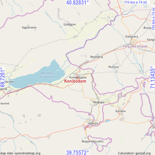
Konibodom GPS coordinates[2]
40° 17' 38.904" North, 70° 25' 52.392" East
| Map corner | latitude | longitude |
|---|---|---|
| Upper-left | 40.82831°, | 69.7281° |
| Center: | 40.29414°, | 70.43122° |
| Lower-right: | 39.75572°, | 71.13435° |
| Map W x H: | 119.3×119.3 km | = 74.1×74.1mi |
| max Lat: | 40.99827° ⇑10.2% North |
| Konibodom: | 40.29414° |
| min Lat: | ⇓89.8% South 36.72484° |
| min Long | Konibodom | max Long |
| 67.60931° | 70.43122° | 73.96674° |
| W 81.8%⇐ | ⇒18.2% E |
Elevation
Elevation of Konibodom is 409 m = 1342 ft, and this is 553.5 m = 1816 ft below average elevation for this country.
| Max E: |
3607 m = 11834 ft | 81.8% |
| Avg. | 962.5 m = 3158 ft | |
| Konibodom | 409 m = 1342 ft | |
Min E: |
324 m = 1063 ft | 18.2% |
See also: Konibodom elevation on elevation.city.
Geographical zone
Konibodom is located in North temperate zone (between Tropic of Cancer and the Arctic Circle). Distance of this Northern Tropic circle is 1874.4 km =1164.7 mi to South.| Distance of | km | miles | from Konibodom |
|---|---|---|---|
| North Pole | 5526.8 | 3434.2 | to North |
| Arctic Circle | 2920.9 | 1815 | to North |
| Tropic Cancer | 1874.4 | 1164.7 | to South |
| Equator | 4480.3 | 2783.9 | to South |


Nearby cities:
15 places around Konibodom: (largest is in red/bold)
• Adrasmon
54.6 km =33.9 mi,  316°
316°
• Chkalov
62.8 km =39 mi,  263°
263°
• Ghafurov
60.3 km =37.5 mi, 261°
• Isfara
24.9 km =15.5 mi,  138°
138°
• Khŭjand
68.6 km =42.6 mi,  268°
268°
• Kim
10.1 km =6.3 mi,  161°
161°
• Konsoy
65.5 km =40.7 mi,  289°
289°
• Navgarzan
78.3 km =48.7 mi,  359°
359°
• Neftobod
14.8 km =9.2 mi,  126°
126°
• Palos
58.9 km =36.6 mi, 272°
• Proletar
80.2 km =49.8 mi, 259°
• Shaydon
42.3 km =26.3 mi,  350°
350°
• Shŭrob
29.1 km =18.1 mi, 161°
• Taboshar
73.5 km =45.7 mi, 294°
• Vorukh
50.8 km =31.6 mi,  165°
165°
Sources, notices
• [Note1] Compared only with cities in Tajikistan existing in our database
• [Src1] Map data: © OpenStreetMap contributors (CC-BY-SA)
• [Src2] Other city data from geonames.org with taken over terms of usage.
• [Src3] Geographical zone / Annual Mean Temperature by Robert A. Rohde @ Wikipedia
