Yazyurdu geodata
Yazyurdu (Sivas) is a seat of a third-order administrative division; located in Turkey in Europe/Istanbul (GMT+3) time zone. In our database, there are 1323 cities with bigger population. Compared to other cities in Turkey, 51.8% of cities are located further ↓South; 56.6% of cities are located further ←West and 96.5% of cities have lower elevation than Yazyurdu. Note1


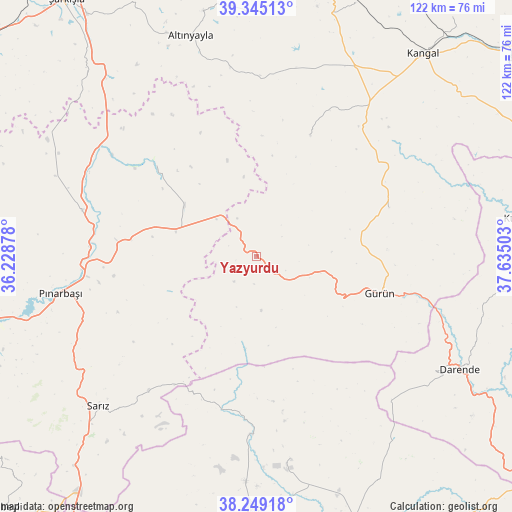
Yazyurdu GPS coordinates[2]
38° 47' 57.336" North, 36° 55' 54.84" East
| Map corner | latitude | longitude |
|---|---|---|
| Upper-left | 39.34513°, | 36.22878° |
| Center: | 38.79926°, | 36.9319° |
| Lower-right: | 38.24918°, | 37.63503° |
| Map W x H: | 121.9×121.9 km | = 75.7×75.7mi |
| max Lat: | 42.02683° ⇑48.2% North |
| Yazyurdu: | 38.79926° |
| min Lat: | ⇓51.8% South 35.9025° |
| min Long | Yazyurdu | max Long |
| 25.90902° | 36.9319° | 44.60099° |
| W 56.6%⇐ | ⇒43.4% E |
Elevation
Elevation of Yazyurdu is 1765 m = 5791 ft, and this is 1047.6 m = 3437 ft above average elevation for this country.
| Max E: |
2682 m = 8799 ft | 3.5% |
| Yazyurdu | 1765 m 5791 ft | |
| Avg. | 717.4 m = 2354 ft | |
Min E: |
0 m = 0 ft | 96.5% |
See also: Turkey elevation on elevation.city.
Geographical zone
Yazyurdu is located in North temperate zone (between Tropic of Cancer and the Arctic Circle). Distance of this Northern Tropic circle is 1708.2 km =1061.4 mi to South.| Distance of | km | miles | from Yazyurdu |
|---|---|---|---|
| North Pole | 5693 | 3537.5 | to North |
| Arctic Circle | 3087.1 | 1918.2 | to North |
| Tropic Cancer | 1708.2 | 1061.4 | to South |
| Equator | 4314.1 | 2680.7 | to South |


Nearby cities:
15 places around Yazyurdu: (largest is in red/bold)
• Afşin
61.3 km =38.1 mi,  181°
181°
• Alacahan
65.3 km =40.6 mi,  58°
58°
• Altınyayla
54.9 km =34.1 mi,  343°
343°
• Darende
57.2 km =35.5 mi,  119°
119°
• Deliktaş
64.7 km =40.2 mi,  21°
21°
• Gürün
30.6 km =19 mi,  106°
106°
• Kangal
62.5 km =38.8 mi,  39°
39°
• Kaynar
42.8 km =26.6 mi,  285°
285°
• Konakpınar
33.8 km =21 mi,  69°
69°
• Kuluncak
63.9 km =39.7 mi,  82°
82°
• Kuşkayası
31.7 km =19.7 mi, 23°
• Pınarbaşı
47.5 km =29.5 mi,  259°
259°
• Sarız
51.8 km =32.2 mi,  226°
226°
• Tanır
42.3 km =26.3 mi, 182°
• Örenşehir
33 km =20.5 mi,  312°
312°
Sources, notices
• [Note1] Compared only with cities in Turkey existing in our database
• [Src1] Map data: © OpenStreetMap contributors (CC-BY-SA)
• [Src2] Other city data from geonames.org with taken over terms of usage.
• [Src3] Geographical zone / Annual Mean Temperature by Robert A. Rohde @ Wikipedia
