Kirando geodata
Kirando (Rukwa) is a populated place; located in Tanzania in Africa/Dar_es_Salaam (GMT+3) time zone. With population of 33,111 people, there are 54 cities with bigger population in this country. Compared to other cities in Tanzania, 69.6% of cities are located further ↑North; 97.2% of cities are located further →East and 64.3% of cities have higher elevation than Kirando. Note1


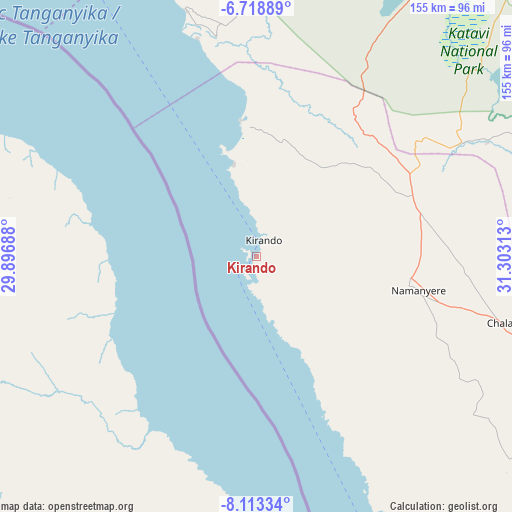
Kirando GPS coordinates[2]
7° 25' 0.012" South, 30° 36' 0" East
| Map corner | latitude | longitude |
|---|---|---|
| Upper-left | -6.71889°, | 29.89688° |
| Center: | -7.41667°, | 30.6° |
| Lower-right: | -8.11334°, | 31.30313° |
| Map W x H: | 155×155.1 km | = 96.3×96.4mi |
| max Lat: | -1.14389° ⇑69.6% North |
| Kirando: | -7.41667° |
| min Lat: | ⇓30.4% South -11.36667° |
| min Long | Kirando | max Long |
| 29.62667° | 30.6° | 40.33333° |
| W 2.8%⇐ | ⇒97.2% E |
Elevation
Elevation of Kirando is 773 m = 2536 ft, and this is 169.8 m = 557 ft below average elevation for this country.
| Max E: |
2377 m = 7799 ft | 64.3% |
| Avg. | 942.8 m = 3093 ft | |
| Kirando | 773 m = 2536 ft | |
Min E: |
0 m = 0 ft | 35.7% |
See also: Tanzania elevation on elevation.city.
Geographical zone
Kirando is located in South Torrid zone (between Equator and Tropic of Capricorn). Distance of Equator is 824.7 km =512.4 mi to North.| Distance of | km | miles | from Kirando |
|---|---|---|---|
| Equator | 824.7 | 512.4 | to North |
| Tropic Capricorn | 1781.3 | 1106.8 | to South |
| Antarctic Circle | 6576.5 | 4086.4 | to South |
| South Pole | 9182.4 | 5705.7 | to South |


Nearby cities:
15 places around Kirando: (largest is in red/bold)
• Chala
75.8 km =47.1 mi,  104°
104°
• Inyonga
179.6 km =111.6 mi,  64°
64°
• Kaliua
293.3 km =182.2 mi,  26°
26°
• Karema
68.6 km =42.6 mi,  344°
344°
• Kigoma
302.2 km =187.8 mi, 339°
• Laela
204.5 km =127.1 mi,  128°
128°
• Matai
140.9 km =87.6 mi, 134°
• Mpanda
130.1 km =80.8 mi,  23°
23°
• Mwandiga
305.9 km =190.1 mi, 340°
• Namanyere
50.8 km =31.6 mi, 102°
• Nguruka
261.2 km =162.3 mi,  10°
10°
• Nkove
65.4 km =40.6 mi,  155°
155°
• Sumbawanga
127.6 km =79.3 mi,  118°
118°
• Usevia
78.2 km =48.6 mi, 63°
• Uvinza
258.2 km =160.4 mi,  354°
354°
Sources, notices
• [Note1] Compared only with cities in Tanzania existing in our database
• [Src1] Map data: © OpenStreetMap contributors (CC-BY-SA)
• [Src2] Other city data from geonames.org with taken over terms of usage.
• [Src3] Geographical zone / Annual Mean Temperature by Robert A. Rohde @ Wikipedia
