Kigoma geodata
Kigoma is a seat of a first-order administrative division; located in Tanzania in Africa/Dar_es_Salaam (GMT+3) time zone. With population of 164,268 people, there are 8 cities with bigger population in this country. Compared to other cities in Tanzania, 57.3% of cities are located further ↓South; 100% of cities are located further →East and 64.7% of cities have higher elevation than Kigoma. Note1


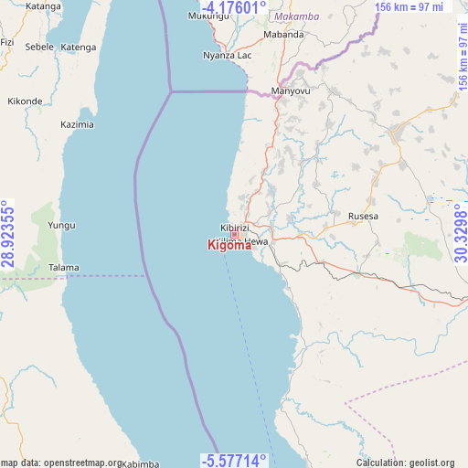
Kigoma GPS coordinates[2]
4° 52' 36.984" South, 29° 37' 36.012" East
| Map corner | latitude | longitude |
|---|---|---|
| Upper-left | -4.17601°, | 28.92355° |
| Center: | -4.87694°, | 29.62667° |
| Lower-right: | -5.57714°, | 30.3298° |
| Map W x H: | 155.8×155.8 km | = 96.8×96.8mi |
| max Lat: | -1.14389° ⇑42.7% North |
| Kigoma: | -4.87694° |
| min Lat: | ⇓57.3% South -11.36667° |
| min Long | Kigoma | max Long |
| 29.62667° | 29.62667° | 40.33333° |
| W 0%⇐ | ⇒100% E |
Elevation
Elevation of Kigoma is 769 m = 2523 ft, and this is 173.8 m = 570 ft below average elevation for this country.
| Max E: |
2377 m = 7799 ft | 64.7% |
| Avg. | 942.8 m = 3093 ft | |
| Kigoma | 769 m = 2523 ft | |
Min E: |
0 m = 0 ft | 35.3% |
See also: Kigoma elevation on elevation.city.
Geographical zone
Kigoma is located in South Torrid zone (between Equator and Tropic of Capricorn). Distance of Equator is 542.3 km =337 mi to North.| Distance of | km | miles | from Kigoma |
|---|---|---|---|
| Equator | 542.3 | 337 | to North |
| Tropic Capricorn | 2063.7 | 1282.3 | to South |
| Antarctic Circle | 6858.9 | 4261.9 | to South |
| South Pole | 9464.8 | 5881.2 | to South |


Nearby cities:
15 places around Kigoma: (largest is in red/bold)
• Bugarama
244.5 km =151.9 mi,  24°
24°
• Kabanga
265.8 km =165.2 mi, 20°
• Kakonko
231.1 km =143.6 mi,  39°
39°
• Kaliua
240.9 km =149.7 mi,  94°
94°
• Karema
234 km =145.4 mi,  157°
157°
• Kasulu
62.4 km =38.8 mi,  57°
57°
• Kibondo
187.9 km =116.8 mi, 40°
• Mabamba
172.1 km =106.9 mi,  34°
34°
• Mpanda
228.2 km =141.8 mi,  135°
135°
• Mwandiga
6.3 km =3.9 mi, 33°
• Nguruka
158.9 km =98.7 mi,  99°
99°
• Rulenge
264.8 km =164.5 mi, 24°
• Urambo
269.3 km =167.3 mi, 94°
• Uvinza
88.3 km =54.9 mi,  106°
106°
• Uyovu
275.2 km =171 mi,  49°
49°
Sources, notices
• [Note1] Compared only with cities in Tanzania existing in our database
• [Src1] Map data: © OpenStreetMap contributors (CC-BY-SA)
• [Src2] Other city data from geonames.org with taken over terms of usage.
• [Src3] Geographical zone / Annual Mean Temperature by Robert A. Rohde @ Wikipedia
