Rulenge geodata
Rulenge (Kagera) is a populated place; located in Tanzania in Africa/Dar_es_Salaam (GMT+3) time zone. With population of 22,069 people, there are 111 cities with bigger population in this country. Compared to other cities in Tanzania, 87.4% of cities are located further ↓South; 96.9% of cities are located further →East and 80.1% of cities have lower elevation than Rulenge. Note1


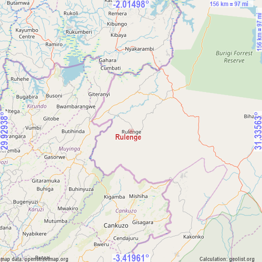
Rulenge GPS coordinates[2]
2° 43' 3" South, 30° 37' 57" East
| Map corner | latitude | longitude |
|---|---|---|
| Upper-left | -2.01498°, | 29.92938° |
| Center: | -2.7175°, | 30.6325° |
| Lower-right: | -3.41961°, | 31.33563° |
| Map W x H: | 156.2×156.2 km | = 97.1×97.1mi |
| max Lat: | -1.14389° ⇑12.6% North |
| Rulenge: | -2.7175° |
| min Lat: | ⇓87.4% South -11.36667° |
| min Long | Rulenge | max Long |
| 29.62667° | 30.6325° | 40.33333° |
| W 3.1%⇐ | ⇒96.9% E |
Elevation
Elevation of Rulenge is 1422 m = 4665 ft, and this is 479.2 m = 1572 ft above average elevation for this country.
| Max E: |
2377 m = 7799 ft | 19.9% |
| Rulenge | 1422 m 4665 ft | |
| Avg. | 942.8 m = 3093 ft | |
Min E: |
0 m = 0 ft | 80.1% |
See also: Tanzania elevation on elevation.city.
Geographical zone
Rulenge is located in South Torrid zone (between Equator and Tropic of Capricorn). Distance of Equator is 302.2 km =187.8 mi to North.| Distance of | km | miles | from Rulenge |
|---|---|---|---|
| Equator | 302.2 | 187.8 | to North |
| Tropic Capricorn | 2303.8 | 1431.5 | to South |
| Antarctic Circle | 7099 | 4411.1 | to South |
| South Pole | 9704.9 | 6030.3 | to South |


Nearby cities:
15 places around Rulenge: (largest is in red/bold)
• Biharamulo
75.7 km =47 mi,  82°
82°
• Bugarama
20.6 km =12.8 mi,  214°
214°
• Bugene
137.4 km =85.4 mi,  24°
24°
• Buseresere
142.1 km =88.3 mi,  103°
103°
• Chato
126.3 km =78.5 mi,  85°
85°
• Kabanga
20.3 km =12.6 mi,  295°
295°
• Kakonko
72.8 km =45.2 mi,  149°
149°
• Katoro
144.3 km =89.7 mi, 103°
• Kibondo
97.1 km =60.3 mi,  174°
174°
• Mabamba
99 km =61.5 mi,  188°
188°
• Muleba
149.7 km =93 mi,  49°
49°
• Ngara
23 km =14.3 mi,  6°
6°
• Nshamba
144.4 km =89.7 mi,  44°
44°
• Nyakahanga
136.2 km =84.6 mi, 24°
• Uyovu
117.5 km =73 mi,  122°
122°
Sources, notices
• [Note1] Compared only with cities in Tanzania existing in our database
• [Src1] Map data: © OpenStreetMap contributors (CC-BY-SA)
• [Src2] Other city data from geonames.org with taken over terms of usage.
• [Src3] Geographical zone / Annual Mean Temperature by Robert A. Rohde @ Wikipedia
