Kabanga geodata
Kabanga (Kagera) is a populated place; located in Tanzania in Africa/Dar_es_Salaam (GMT+3) time zone. With population of 19,421 people, there are 132 cities with bigger population in this country. Compared to other cities in Tanzania, 88.5% of cities are located further ↓South; 98.3% of cities are located further →East and 89.9% of cities have lower elevation than Kabanga. Note1


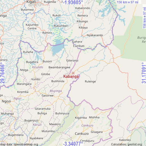
Kabanga GPS coordinates[2]
2° 38' 18.996" South, 30° 28' 4.008" East
| Map corner | latitude | longitude |
|---|---|---|
| Upper-left | -1.93605°, | 29.76466° |
| Center: | -2.63861°, | 30.46778° |
| Lower-right: | -3.34077°, | 31.17091° |
| Map W x H: | 156.2×156.2 km | = 97.1×97.1mi |
| max Lat: | -1.14389° ⇑11.5% North |
| Kabanga: | -2.63861° |
| min Lat: | ⇓88.5% South -11.36667° |
| min Long | Kabanga | max Long |
| 29.62667° | 30.46778° | 40.33333° |
| W 1.7%⇐ | ⇒98.3% E |
Elevation
Elevation of Kabanga is 1608 m = 5276 ft, and this is 665.2 m = 2182 ft above average elevation for this country.
| Max E: |
2377 m = 7799 ft | 10.1% |
| Kabanga | 1608 m 5276 ft | |
| Avg. | 942.8 m = 3093 ft | |
Min E: |
0 m = 0 ft | 89.9% |
See also: Tanzania elevation on elevation.city.
Geographical zone
Kabanga is located in South Torrid zone (between Equator and Tropic of Capricorn). Distance of Equator is 293.4 km =182.3 mi to North.| Distance of | km | miles | from Kabanga |
|---|---|---|---|
| Equator | 293.4 | 182.3 | to North |
| Tropic Capricorn | 2312.5 | 1436.9 | to South |
| Antarctic Circle | 7107.8 | 4416.6 | to South |
| South Pole | 9713.7 | 6035.8 | to South |


Nearby cities:
15 places around Kabanga: (largest is in red/bold)
• Biharamulo
93.4 km =58 mi,  89°
89°
• Bugarama
26.6 km =16.5 mi,  165°
165°
• Bugene
138.4 km =86 mi,  32°
32°
• Buseresere
162 km =100.7 mi,  105°
105°
• Chato
144.3 km =89.7 mi, 89°
• Kakonko
90.4 km =56.2 mi,  142°
142°
• Katoro
164.2 km =102 mi,  104°
104°
• Kibondo
109 km =67.7 mi, 165°
• Mabamba
106.8 km =66.4 mi,  177°
177°
• Muleba
159 km =98.8 mi,  56°
56°
• Ngara
25.2 km =15.7 mi, 56°
• Nshamba
152.4 km =94.7 mi,  52°
52°
• Nyakahanga
137.3 km =85.3 mi, 33°
• Rulenge
20.3 km =12.6 mi,  115°
115°
• Uyovu
137.6 km =85.5 mi, 121°
Sources, notices
• [Note1] Compared only with cities in Tanzania existing in our database
• [Src1] Map data: © OpenStreetMap contributors (CC-BY-SA)
• [Src2] Other city data from geonames.org with taken over terms of usage.
• [Src3] Geographical zone / Annual Mean Temperature by Robert A. Rohde @ Wikipedia
