Katerero geodata
Katerero (Kagera) is a populated place; located in Tanzania in Africa/Dar_es_Salaam (GMT+3) time zone. With population of 18,430 people, there are 148 cities with bigger population in this country. Compared to other cities in Tanzania, 97.9% of cities are located further ↓South; 89.2% of cities are located further →East and 55.9% of cities have lower elevation than Katerero. Note1


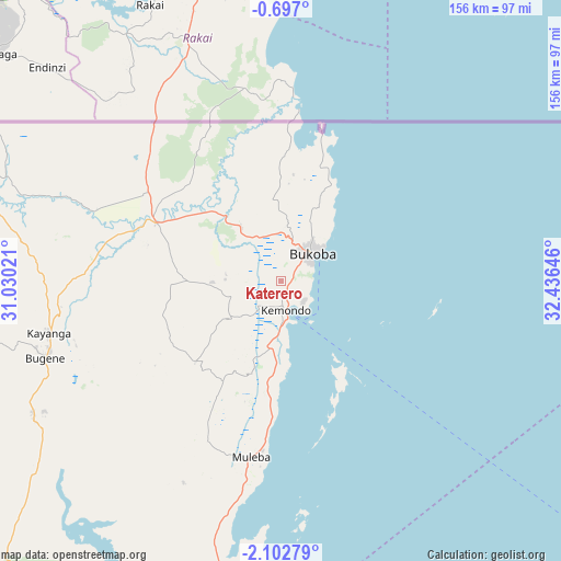
Katerero GPS coordinates[2]
1° 24' 0" South, 31° 43' 59.988" East
| Map corner | latitude | longitude |
|---|---|---|
| Upper-left | -0.697°, | 31.03021° |
| Center: | -1.4°, | 31.73333° |
| Lower-right: | -2.10279°, | 32.43646° |
| Map W x H: | 156.3×156.3 km | = 97.1×97.1mi |
| max Lat: | -1.14389° ⇑2.1% North |
| Katerero: | -1.4° |
| min Lat: | ⇓97.9% South -11.36667° |
| min Long | Katerero | max Long |
| 29.62667° | 31.73333° | 40.33333° |
| W 10.8%⇐ | ⇒89.2% E |
Elevation
Elevation of Katerero is 1164 m = 3819 ft, and this is 221.2 m = 726 ft above average elevation for this country.
| Max E: |
2377 m = 7799 ft | 44.1% |
| Katerero | 1164 m 3819 ft | |
| Avg. | 942.8 m = 3093 ft | |
Min E: |
0 m = 0 ft | 55.9% |
See also: Tanzania elevation on elevation.city.
Geographical zone
Katerero is located in South Torrid zone (between Equator and Tropic of Capricorn). Distance of Equator is 155.7 km =96.7 mi to North.| Distance of | km | miles | from Katerero |
|---|---|---|---|
| Equator | 155.7 | 96.7 | to North |
| Tropic Capricorn | 2450.3 | 1522.5 | to South |
| Antarctic Circle | 7245.5 | 4502.1 | to South |
| South Pole | 9851.4 | 6121.4 | to South |


Nearby cities:
15 places around Katerero: (largest is in red/bold)
• Biharamulo
144.9 km =90 mi,  198°
198°
• Bugene
69.3 km =43.1 mi,  252°
252°
• Bukoba
11.6 km =7.2 mi,  49°
49°
• Bukonyo
146.7 km =91.2 mi,  114°
114°
• Chato
137.7 km =85.6 mi,  178°
178°
• Kamachumu
27.4 km =17 mi,  207°
207°
• Katoro
25.9 km =16.1 mi,  270°
270°
• Kyaka
38.5 km =23.9 mi,  295°
295°
• Muleba
49.7 km =30.9 mi,  190°
190°
• Muriti
146.6 km =91.1 mi,  116°
116°
• Nakatunguru
168.2 km =104.5 mi, 118°
• Nansio
167.5 km =104.1 mi, 119°
• Nshamba
48.7 km =30.3 mi, 204°
• Nsunga
47.2 km =29.3 mi,  307°
307°
• Nyakahanga
69.6 km =43.2 mi, 251°
Sources, notices
• [Note1] Compared only with cities in Tanzania existing in our database
• [Src1] Map data: © OpenStreetMap contributors (CC-BY-SA)
• [Src2] Other city data from geonames.org with taken over terms of usage.
• [Src3] Geographical zone / Annual Mean Temperature by Robert A. Rohde @ Wikipedia
