Bugene geodata
Bugene (Kagera) is a populated place; located in Tanzania in Africa/Dar_es_Salaam (GMT+3) time zone. With population of 10,609 people, there are 232 cities with bigger population in this country. Compared to other cities in Tanzania, 97.2% of cities are located further ↓South; 94.1% of cities are located further →East and 92% of cities have lower elevation than Bugene. Note1


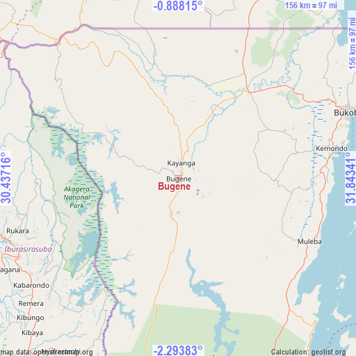
Bugene GPS coordinates[2]
1° 35' 27.996" South, 31° 8' 25.008" East
| Map corner | latitude | longitude |
|---|---|---|
| Upper-left | -0.88815°, | 30.43716° |
| Center: | -1.59111°, | 31.14028° |
| Lower-right: | -2.29383°, | 31.84341° |
| Map W x H: | 156.3×156.3 km | = 97.1×97.1mi |
| max Lat: | -1.14389° ⇑2.8% North |
| Bugene: | -1.59111° |
| min Lat: | ⇓97.2% South -11.36667° |
| min Long | Bugene | max Long |
| 29.62667° | 31.14028° | 40.33333° |
| W 5.9%⇐ | ⇒94.1% E |
Elevation
Elevation of Bugene is 1639 m = 5377 ft, and this is 696.2 m = 2284 ft above average elevation for this country.
| Max E: |
2377 m = 7799 ft | 8% |
| Bugene | 1639 m 5377 ft | |
| Avg. | 942.8 m = 3093 ft | |
Min E: |
0 m = 0 ft | 92% |
See also: Tanzania elevation on elevation.city.
Geographical zone
Bugene is located in South Torrid zone (between Equator and Tropic of Capricorn). Distance of Equator is 176.9 km =109.9 mi to North.| Distance of | km | miles | from Bugene |
|---|---|---|---|
| Equator | 176.9 | 109.9 | to North |
| Tropic Capricorn | 2429 | 1509.3 | to South |
| Antarctic Circle | 7224.3 | 4489 | to South |
| South Pole | 9830.1 | 6108.1 | to South |


Nearby cities:
15 places around Bugene: (largest is in red/bold)
• Biharamulo
117.2 km =72.8 mi,  170°
170°
• Bugarama
157.7 km =98 mi,  205°
205°
• Bukoba
80.1 km =49.8 mi,  68°
68°
• Chato
135.6 km =84.3 mi,  149°
149°
• Kabanga
138.4 km =86 mi, 212°
• Kamachumu
53.4 km =33.2 mi,  93°
93°
• Katerero
69.3 km =43.1 mi, 72°
• Katoro
45.3 km =28.1 mi,  61°
61°
• Kyaka
48.9 km =30.4 mi,  39°
39°
• Muleba
63.5 km =39.5 mi,  115°
115°
• Ngara
115.7 km =71.9 mi, 207°
• Nshamba
51.1 km =31.8 mi, 116°
• Nsunga
57.2 km =35.5 mi,  29°
29°
• Nyakahanga
1.4 km =0.9 mi, 174°
• Rulenge
137.4 km =85.4 mi,  204°
204°
Sources, notices
• [Note1] Compared only with cities in Tanzania existing in our database
• [Src1] Map data: © OpenStreetMap contributors (CC-BY-SA)
• [Src2] Other city data from geonames.org with taken over terms of usage.
• [Src3] Geographical zone / Annual Mean Temperature by Robert A. Rohde @ Wikipedia
