Kamachumu geodata
Kamachumu (Kagera) is a populated place; located in Tanzania in Africa/Dar_es_Salaam (GMT+3) time zone. With population of 15,701 people, there are 178 cities with bigger population in this country. Compared to other cities in Tanzania, 96.5% of cities are located further ↓South; 89.9% of cities are located further →East and 83.2% of cities have lower elevation than Kamachumu. Note1


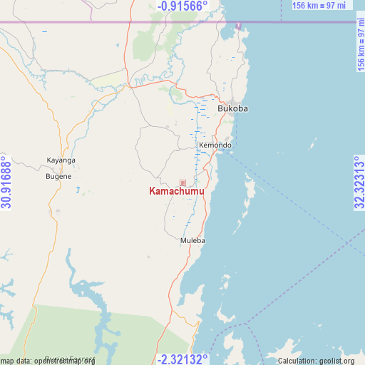
Kamachumu GPS coordinates[2]
1° 37' 6.996" South, 31° 37' 12" East
| Map corner | latitude | longitude |
|---|---|---|
| Upper-left | -0.91566°, | 30.91688° |
| Center: | -1.61861°, | 31.62° |
| Lower-right: | -2.32132°, | 32.32313° |
| Map W x H: | 156.3×156.3 km | = 97.1×97.1mi |
| max Lat: | -1.14389° ⇑3.5% North |
| Kamachumu: | -1.61861° |
| min Lat: | ⇓96.5% South -11.36667° |
| min Long | Kamachumu | max Long |
| 29.62667° | 31.62° | 40.33333° |
| W 10.1%⇐ | ⇒89.9% E |
Elevation
Elevation of Kamachumu is 1496 m = 4908 ft, and this is 553.2 m = 1815 ft above average elevation for this country.
| Max E: |
2377 m = 7799 ft | 16.8% |
| Kamachumu | 1496 m 4908 ft | |
| Avg. | 942.8 m = 3093 ft | |
Min E: |
0 m = 0 ft | 83.2% |
See also: Tanzania elevation on elevation.city.
Geographical zone
Kamachumu is located in South Torrid zone (between Equator and Tropic of Capricorn). Distance of Equator is 180 km =111.8 mi to North.| Distance of | km | miles | from Kamachumu |
|---|---|---|---|
| Equator | 180 | 111.8 | to North |
| Tropic Capricorn | 2425.9 | 1507.4 | to South |
| Antarctic Circle | 7221.2 | 4487 | to South |
| South Pole | 9827.1 | 6106.3 | to South |


Nearby cities:
15 places around Kamachumu: (largest is in red/bold)
• Biharamulo
117.9 km =73.3 mi,  197°
197°
• Bugene
53.4 km =33.2 mi,  273°
273°
• Bukoba
38.4 km =23.9 mi,  33°
33°
• Bukonyo
150.5 km =93.5 mi,  104°
104°
• Chato
114.5 km =71.1 mi,  171°
171°
• Geita
155.1 km =96.4 mi,  153°
153°
• Katerero
27.4 km =17 mi, 27°
• Katoro
27.7 km =17.2 mi,  331°
331°
• Kyaka
46.4 km =28.8 mi, 331°
• Muleba
24.9 km =15.5 mi, 171°
• Muriti
149.7 km =93 mi,  105°
105°
• Ngara
146.1 km =90.8 mi,  227°
227°
• Nshamba
21.4 km =13.3 mi, 200°
• Nsunga
58.4 km =36.3 mi, 334°
• Nyakahanga
53.2 km =33.1 mi, 271°
Sources, notices
• [Note1] Compared only with cities in Tanzania existing in our database
• [Src1] Map data: © OpenStreetMap contributors (CC-BY-SA)
• [Src2] Other city data from geonames.org with taken over terms of usage.
• [Src3] Geographical zone / Annual Mean Temperature by Robert A. Rohde @ Wikipedia
