Bukoba geodata
Bukoba (Kagera) is a seat of a first-order administrative division; located in Tanzania in Africa/Dar_es_Salaam (GMT+3) time zone. With population of 70,628 people, there are 22 cities with bigger population in this country. Compared to other cities in Tanzania, 99% of cities are located further ↓South; 88.1% of cities are located further →East and 52.8% of cities have lower elevation than Bukoba. Note1


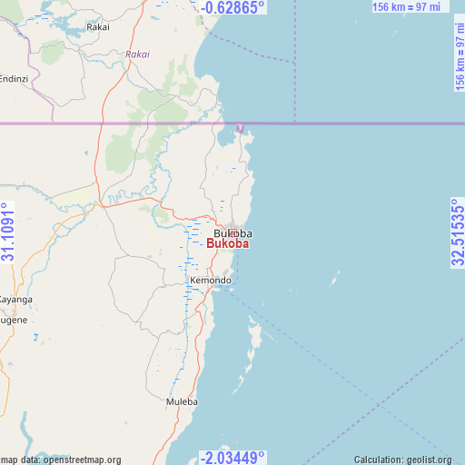
Bukoba GPS coordinates[2]
1° 19' 54.012" South, 31° 48' 43.992" East
| Map corner | latitude | longitude |
|---|---|---|
| Upper-left | -0.62865°, | 31.1091° |
| Center: | -1.33167°, | 31.81222° |
| Lower-right: | -2.03449°, | 32.51535° |
| Map W x H: | 156.3×156.3 km | = 97.1×97.1mi |
| max Lat: | -1.14389° ⇑1% North |
| Bukoba: | -1.33167° |
| min Lat: | ⇓99% South -11.36667° |
| min Long | Bukoba | max Long |
| 29.62667° | 31.81222° | 40.33333° |
| W 11.9%⇐ | ⇒88.1% E |
Elevation
Elevation of Bukoba is 1149 m = 3770 ft, and this is 206.2 m = 677 ft above average elevation for this country.
| Max E: |
2377 m = 7799 ft | 47.2% |
| Bukoba | 1149 m 3770 ft | |
| Avg. | 942.8 m = 3093 ft | |
Min E: |
0 m = 0 ft | 52.8% |
See also: Bukoba elevation on elevation.city.
Geographical zone
Bukoba is located in South Torrid zone (between Equator and Tropic of Capricorn). Distance of Equator is 148.1 km =92 mi to North.| Distance of | km | miles | from Bukoba |
|---|---|---|---|
| Equator | 148.1 | 92 | to North |
| Tropic Capricorn | 2457.9 | 1527.3 | to South |
| Antarctic Circle | 7253.1 | 4506.9 | to South |
| South Pole | 9859 | 6126.1 | to South |


Nearby cities:
15 places around Bukoba: (largest is in red/bold)
• Biharamulo
155 km =96.3 mi,  201°
201°
• Bugene
80.1 km =49.8 mi,  248°
248°
• Bukonyo
142.3 km =88.4 mi,  118°
118°
• Chato
145.3 km =90.3 mi,  181°
181°
• Kamachumu
38.4 km =23.9 mi,  213°
213°
• Katerero
11.6 km =7.2 mi,  229°
229°
• Katoro
35.5 km =22.1 mi,  257°
257°
• Kyaka
44.5 km =27.7 mi,  281°
281°
• Muleba
59.1 km =36.7 mi, 197°
• Muriti
142.5 km =88.5 mi, 120°
• Nakatunguru
164.5 km =102.2 mi, 122°
• Nansio
163.9 km =101.8 mi, 122°
• Nshamba
59.5 km =37 mi, 209°
• Nsunga
50.9 km =31.6 mi,  294°
294°
• Nyakahanga
80.5 km =50 mi, 247°
Sources, notices
• [Note1] Compared only with cities in Tanzania existing in our database
• [Src1] Map data: © OpenStreetMap contributors (CC-BY-SA)
• [Src2] Other city data from geonames.org with taken over terms of usage.
• [Src3] Geographical zone / Annual Mean Temperature by Robert A. Rohde @ Wikipedia
