Muleba geodata
Muleba (Kagera) is a populated place; located in Tanzania in Africa/Dar_es_Salaam (GMT+3) time zone. With population of 11,555 people, there are 221 cities with bigger population in this country. Compared to other cities in Tanzania, 95.1% of cities are located further ↓South; 89.5% of cities are located further →East and 68.9% of cities have lower elevation than Muleba. Note1


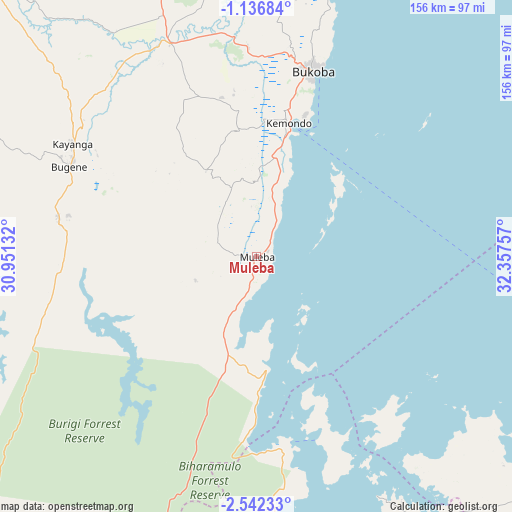
Muleba GPS coordinates[2]
1° 50' 22.992" South, 31° 39' 15.984" East
| Map corner | latitude | longitude |
|---|---|---|
| Upper-left | -1.13684°, | 30.95132° |
| Center: | -1.83972°, | 31.65444° |
| Lower-right: | -2.54233°, | 32.35757° |
| Map W x H: | 156.3×156.3 km | = 97.1×97.1mi |
| max Lat: | -1.14389° ⇑4.9% North |
| Muleba: | -1.83972° |
| min Lat: | ⇓95.1% South -11.36667° |
| min Long | Muleba | max Long |
| 29.62667° | 31.65444° | 40.33333° |
| W 10.5%⇐ | ⇒89.5% E |
Elevation
Elevation of Muleba is 1270 m = 4167 ft, and this is 327.2 m = 1073 ft above average elevation for this country.
| Max E: |
2377 m = 7799 ft | 31.1% |
| Muleba | 1270 m 4167 ft | |
| Avg. | 942.8 m = 3093 ft | |
Min E: |
0 m = 0 ft | 68.9% |
See also: Tanzania elevation on elevation.city.
Geographical zone
Muleba is located in South Torrid zone (between Equator and Tropic of Capricorn). Distance of Equator is 204.6 km =127.1 mi to North.| Distance of | km | miles | from Muleba |
|---|---|---|---|
| Equator | 204.6 | 127.1 | to North |
| Tropic Capricorn | 2401.4 | 1492.2 | to South |
| Antarctic Circle | 7196.6 | 4471.8 | to South |
| South Pole | 9802.5 | 6091 | to South |


Nearby cities:
15 places around Muleba: (largest is in red/bold)
• Biharamulo
96.1 km =59.7 mi,  203°
203°
• Bugene
63.5 km =39.5 mi,  295°
295°
• Bukoba
59.1 km =36.7 mi,  17°
17°
• Buseresere
133.9 km =83.2 mi,  169°
169°
• Chato
89.6 km =55.7 mi, 171°
• Geita
131.6 km =81.8 mi,  150°
150°
• Kamachumu
24.9 km =15.5 mi,  351°
351°
• Katerero
49.7 km =30.9 mi,  10°
10°
• Katoro
51.8 km =32.2 mi,  340°
340°
• Katoro
134 km =83.3 mi, 168°
• Kyaka
70.3 km =43.7 mi, 338°
• Ngara
133.8 km =83.1 mi,  236°
236°
• Nshamba
12.4 km =7.7 mi,  291°
291°
• Nsunga
82.6 km =51.3 mi, 339°
• Nyakahanga
62.8 km =39 mi, 294°
Sources, notices
• [Note1] Compared only with cities in Tanzania existing in our database
• [Src1] Map data: © OpenStreetMap contributors (CC-BY-SA)
• [Src2] Other city data from geonames.org with taken over terms of usage.
• [Src3] Geographical zone / Annual Mean Temperature by Robert A. Rohde @ Wikipedia
