Nyakahanga geodata
Nyakahanga (Kagera) is a populated place; located in Tanzania in Africa/Dar_es_Salaam (GMT+3) time zone. With population of 14,611 people, there are 186 cities with bigger population in this country. Compared to other cities in Tanzania, 96.9% of cities are located further ↓South; 93.7% of cities are located further →East and 93.4% of cities have lower elevation than Nyakahanga. Note1


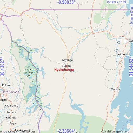
Nyakahanga GPS coordinates[2]
1° 36' 11.988" South, 31° 8' 29.004" East
| Map corner | latitude | longitude |
|---|---|---|
| Upper-left | -0.90038°, | 30.43827° |
| Center: | -1.60333°, | 31.14139° |
| Lower-right: | -2.30604°, | 31.84452° |
| Map W x H: | 156.3×156.3 km | = 97.1×97.1mi |
| max Lat: | -1.14389° ⇑3.1% North |
| Nyakahanga: | -1.60333° |
| min Lat: | ⇓96.9% South -11.36667° |
| min Long | Nyakahanga | max Long |
| 29.62667° | 31.14139° | 40.33333° |
| W 6.3%⇐ | ⇒93.7% E |
Elevation
Elevation of Nyakahanga is 1662 m = 5453 ft, and this is 719.2 m = 2360 ft above average elevation for this country.
| Max E: |
2377 m = 7799 ft | 6.6% |
| Nyakahanga | 1662 m 5453 ft | |
| Avg. | 942.8 m = 3093 ft | |
Min E: |
0 m = 0 ft | 93.4% |
See also: Tanzania elevation on elevation.city.
Geographical zone
Nyakahanga is located in South Torrid zone (between Equator and Tropic of Capricorn). Distance of Equator is 178.3 km =110.8 mi to North.| Distance of | km | miles | from Nyakahanga |
|---|---|---|---|
| Equator | 178.3 | 110.8 | to North |
| Tropic Capricorn | 2427.6 | 1508.4 | to South |
| Antarctic Circle | 7222.9 | 4488.1 | to South |
| South Pole | 9828.8 | 6107.3 | to South |


Nearby cities:
15 places around Nyakahanga: (largest is in red/bold)
• Biharamulo
115.9 km =72 mi,  170°
170°
• Bugarama
156.5 km =97.2 mi,  205°
205°
• Bugene
1.4 km =0.9 mi,  354°
354°
• Bukoba
80.5 km =50 mi,  67°
67°
• Chato
134.4 km =83.5 mi,  148°
148°
• Kabanga
137.3 km =85.3 mi, 213°
• Kamachumu
53.2 km =33.1 mi,  91°
91°
• Katerero
69.6 km =43.2 mi, 71°
• Katoro
45.9 km =28.5 mi,  60°
60°
• Kyaka
49.9 km =31 mi,  38°
38°
• Muleba
62.8 km =39 mi,  114°
114°
• Ngara
114.6 km =71.2 mi, 208°
• Nshamba
50.4 km =31.3 mi,  115°
115°
• Nsunga
58.3 km =36.2 mi,  28°
28°
• Rulenge
136.2 km =84.6 mi,  204°
204°
Sources, notices
• [Note1] Compared only with cities in Tanzania existing in our database
• [Src1] Map data: © OpenStreetMap contributors (CC-BY-SA)
• [Src2] Other city data from geonames.org with taken over terms of usage.
• [Src3] Geographical zone / Annual Mean Temperature by Robert A. Rohde @ Wikipedia
