Ngara geodata
Ngara (Kagera) is a populated place; located in Tanzania in Africa/Dar_es_Salaam (GMT+3) time zone. With population of 16,890 people, there are 166 cities with bigger population in this country. Compared to other cities in Tanzania, 91.3% of cities are located further ↓South; 96.5% of cities are located further →East and 96.9% of cities have lower elevation than Ngara. Note1


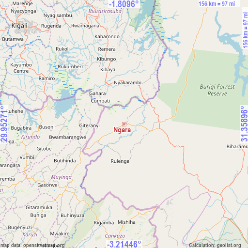
Ngara GPS coordinates[2]
2° 30' 43.992" South, 30° 39' 20.988" East
| Map corner | latitude | longitude |
|---|---|---|
| Upper-left | -1.8096°, | 29.95271° |
| Center: | -2.51222°, | 30.65583° |
| Lower-right: | -3.21446°, | 31.35896° |
| Map W x H: | 156.2×156.2 km | = 97.1×97.1mi |
| max Lat: | -1.14389° ⇑8.7% North |
| Ngara: | -2.51222° |
| min Lat: | ⇓91.3% South -11.36667° |
| min Long | Ngara | max Long |
| 29.62667° | 30.65583° | 40.33333° |
| W 3.5%⇐ | ⇒96.5% E |
Elevation
Elevation of Ngara is 1814 m = 5951 ft, and this is 871.2 m = 2858 ft above average elevation for this country.
| Max E: |
2377 m = 7799 ft | 3.1% |
| Ngara | 1814 m 5951 ft | |
| Avg. | 942.8 m = 3093 ft | |
Min E: |
0 m = 0 ft | 96.9% |
See also: Tanzania elevation on elevation.city.
Geographical zone
Ngara is located in South Torrid zone (between Equator and Tropic of Capricorn). Distance of Equator is 279.3 km =173.5 mi to North.| Distance of | km | miles | from Ngara |
|---|---|---|---|
| Equator | 279.3 | 173.5 | to North |
| Tropic Capricorn | 2326.6 | 1445.7 | to South |
| Antarctic Circle | 7121.8 | 4425.3 | to South |
| South Pole | 9727.7 | 6044.5 | to South |


Nearby cities:
15 places around Ngara: (largest is in red/bold)
• Biharamulo
73.8 km =45.9 mi,  100°
100°
• Bugarama
42.3 km =26.3 mi,  199°
199°
• Bugene
115.7 km =71.9 mi,  27°
27°
• Buseresere
146.8 km =91.2 mi,  112°
112°
• Chato
124.2 km =77.2 mi, 96°
• Kabanga
25.2 km =15.7 mi,  236°
236°
• Kakonko
92.3 km =57.4 mi,  158°
158°
• Kamachumu
146.1 km =90.8 mi,  47°
47°
• Kibondo
119.7 km =74.4 mi,  176°
176°
• Mabamba
122 km =75.8 mi,  188°
188°
• Muleba
133.8 km =83.1 mi,  56°
56°
• Nshamba
127.3 km =79.1 mi, 51°
• Nyakahanga
114.6 km =71.2 mi, 28°
• Rulenge
23 km =14.3 mi, 186°
• Uyovu
129.2 km =80.3 mi,  131°
131°
Sources, notices
• [Note1] Compared only with cities in Tanzania existing in our database
• [Src1] Map data: © OpenStreetMap contributors (CC-BY-SA)
• [Src2] Other city data from geonames.org with taken over terms of usage.
• [Src3] Geographical zone / Annual Mean Temperature by Robert A. Rohde @ Wikipedia
