Zin’kiv geodata
Zin’kiv (Poltava) is a seat of a second-order administrative division; located in Ukraine in Europe/Kiev (GMT+3) time zone. With population of 10,393 people, there are 348 cities with bigger population in this country. Compared to other cities in Ukraine, 86.5% of cities are located further ↓South; 71.2% of cities are located further ←West and 56.9% of cities have higher elevation than Zin’kiv. Note1


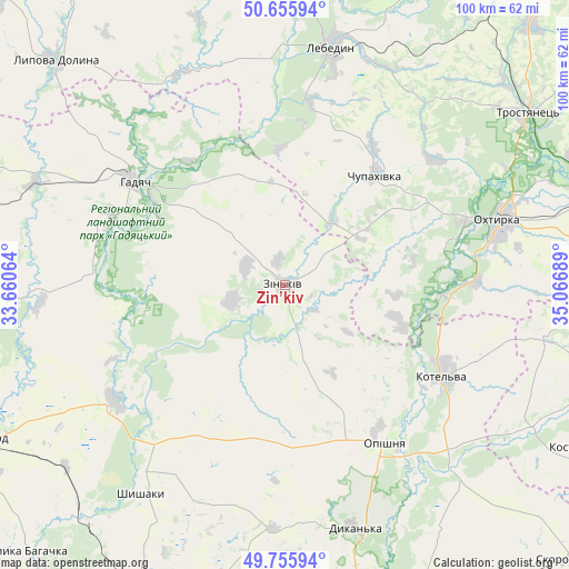
Zin’kiv GPS coordinates[2]
50° 12' 29.016" North, 34° 21' 49.536" East
| Map corner | latitude | longitude |
|---|---|---|
| Upper-left | 50.65594°, | 33.66064° |
| Center: | 50.20806°, | 34.36376° |
| Lower-right: | 49.75594°, | 35.06689° |
| Map W x H: | 100.1×100.1 km | = 62.2×62.2mi |
| max Lat: | 52.18903° ⇑13.5% North |
| Zin’kiv: | 50.20806° |
| min Lat: | ⇓86.5% South 44.39214° |
| min Long | Zin’kiv | max Long |
| 22.20555° | 34.36376° | 40.13222° |
| W 71.2%⇐ | ⇒28.8% E |
Elevation
Elevation of Zin’kiv is 115 m = 377 ft, and this is 40.8 m = 134 ft below average elevation for this country.
| Max E: |
886 m = 2907 ft | 56.9% |
| Avg. | 155.8 m = 511 ft | |
| Zin’kiv | 115 m = 377 ft | |
Min E: |
-3 m = -10 ft | 43.1% |
See also: Ukraine elevation on elevation.city.
Geographical zone
Zin’kiv is located in North temperate zone (between Tropic of Cancer and the Arctic Circle). Distance of this North polar circle is 1818.6 km =1130 mi to North.| Distance of | km | miles | from Zin’kiv |
|---|---|---|---|
| North Pole | 4424.4 | 2749.2 | to North |
| Arctic Circle | 1818.6 | 1130 | to North |
| Tropic Cancer | 2976.7 | 1849.6 | to South |
| Equator | 5582.6 | 3468.9 | to South |


Nearby cities:
15 places around Zin’kiv: (largest is in red/bold)
• Boromlya
62.7 km =39 mi,  43°
43°
• Dykan’ka
44.2 km =27.5 mi,  164°
164°
• Hadyach
32.1 km =19.9 mi,  304°
304°
• Komyshnya
48.6 km =30.2 mi,  266°
266°
• Kotel’va
32.1 km =19.9 mi,  118°
118°
• Krasnokuts’k
59.1 km =36.7 mi,  105°
105°
• Kyrykivka
56.1 km =34.9 mi,  71°
71°
• Lebedyn
42.8 km =26.6 mi,  11°
11°
• Lypova Dolyna
56.4 km =35 mi,  314°
314°
• Myrhorod
60.1 km =37.3 mi,  243°
243°
• Okhtyrka
39.7 km =24.7 mi, 73°
• Oposhnya
33.1 km =20.6 mi,  147°
147°
• Shyshaky
44.2 km =27.5 mi,  214°
214°
• Trostyanets’
52.6 km =32.7 mi,  54°
54°
• Velyki Sorochyntsi
36.5 km =22.7 mi, 235°
Sources, notices
• [Note1] Compared only with cities in Ukraine existing in our database
• [Src1] Map data: © OpenStreetMap contributors (CC-BY-SA)
• [Src2] Other city data from geonames.org with taken over terms of usage.
• [Src3] Geographical zone / Annual Mean Temperature by Robert A. Rohde @ Wikipedia
