Komyshnya geodata
Komyshnya (Poltava) is a populated place; located in Ukraine in Europe/Kiev (GMT+3) time zone. With population of 2,539 people, there are 1026 cities with bigger population in this country. Compared to other cities in Ukraine, 86.3% of cities are located further ↓South; 55% of cities are located further ←West and 51.9% of cities have lower elevation than Komyshnya. Note1


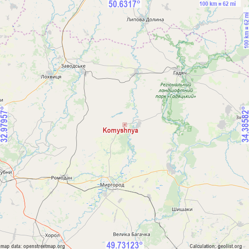
Komyshnya GPS coordinates[2]
50° 11' 0.924" North, 33° 40' 57.684" East
| Map corner | latitude | longitude |
|---|---|---|
| Upper-left | 50.6317°, | 32.97957° |
| Center: | 50.18359°, | 33.68269° |
| Lower-right: | 49.73123°, | 34.38582° |
| Map W x H: | 100.1×100.1 km | = 62.2×62.2mi |
| max Lat: | 52.18903° ⇑13.7% North |
| Komyshnya: | 50.18359° |
| min Lat: | ⇓86.3% South 44.39214° |
| min Long | Komyshnya | max Long |
| 22.20555° | 33.68269° | 40.13222° |
| W 55%⇐ | ⇒45% E |
Elevation
Elevation of Komyshnya is 141 m = 463 ft, and this is 14.8 m = 49 ft below average elevation for this country.
| Max E: |
886 m = 2907 ft | 48.1% |
| Avg. | 155.8 m = 511 ft | |
| Komyshnya | 141 m = 463 ft | |
Min E: |
-3 m = -10 ft | 51.9% |
See also: Ukraine elevation on elevation.city.
Geographical zone
Komyshnya is located in North temperate zone (between Tropic of Cancer and the Arctic Circle). Distance of this North polar circle is 1821.3 km =1131.7 mi to North.| Distance of | km | miles | from Komyshnya |
|---|---|---|---|
| North Pole | 4427.2 | 2750.9 | to North |
| Arctic Circle | 1821.3 | 1131.7 | to North |
| Tropic Cancer | 2974 | 1848 | to South |
| Equator | 5579.9 | 3467.2 | to South |


Nearby cities:
15 places around Komyshnya: (largest is in red/bold)
• Chornukhy
53.5 km =33.2 mi,  280°
280°
• Hadyach
30.2 km =18.8 mi,  46°
46°
• Khorol
53 km =32.9 mi,  213°
213°
• Lokhvytsya
36.3 km =22.6 mi,  304°
304°
• Lubny
52.3 km =32.5 mi,  249°
249°
• Lypova Dolyna
43.1 km =26.8 mi,  10°
10°
• Myrhorod
24.5 km =15.2 mi,  192°
192°
• Oposhnya
71 km =44.1 mi,  110°
110°
• Romny
64.8 km =40.3 mi,  346°
346°
• Romodan
33.3 km =20.7 mi,  229°
229°
• Sencha
25.2 km =15.7 mi,  288°
288°
• Shyshaky
40.9 km =25.4 mi,  145°
145°
• Velyka Bahachka
43.7 km =27.2 mi,  176°
176°
• Velyki Sorochyntsi
25.7 km =16 mi,  134°
134°
• Zin’kiv
48.6 km =30.2 mi,  86°
86°
Sources, notices
• [Note1] Compared only with cities in Ukraine existing in our database
• [Src1] Map data: © OpenStreetMap contributors (CC-BY-SA)
• [Src2] Other city data from geonames.org with taken over terms of usage.
• [Src3] Geographical zone / Annual Mean Temperature by Robert A. Rohde @ Wikipedia
