Shyshaky geodata
Shyshaky (Poltava) is a populated place; located in Ukraine in Europe/Kiev (GMT+3) time zone. With population of 5,671 people, there are 591 cities with bigger population in this country. Compared to other cities in Ukraine, 81.3% of cities are located further ↓South; 63.1% of cities are located further ←West and 54% of cities have lower elevation than Shyshaky. Note1


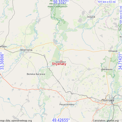
Shyshaky GPS coordinates[2]
49° 52' 54.3" North, 34° 0' 40.248" East
| Map corner | latitude | longitude |
|---|---|---|
| Upper-left | 50.3327°, | 33.30806° |
| Center: | 49.88175°, | 34.01118° |
| Lower-right: | 49.42655°, | 34.71431° |
| Map W x H: | 100.8×100.8 km | = 62.6×62.6mi |
| max Lat: | 52.18903° ⇑18.7% North |
| Shyshaky: | 49.88175° |
| min Lat: | ⇓81.3% South 44.39214° |
| min Long | Shyshaky | max Long |
| 22.20555° | 34.01118° | 40.13222° |
| W 63.1%⇐ | ⇒36.9% E |
Elevation
Elevation of Shyshaky is 150 m = 492 ft, and this is 5.8 m = 19 ft below average elevation for this country.
| Max E: |
886 m = 2907 ft | 46% |
| Avg. | 155.8 m = 511 ft | |
| Shyshaky | 150 m = 492 ft | |
Min E: |
-3 m = -10 ft | 54% |
See also: Ukraine elevation on elevation.city.
Geographical zone
Shyshaky is located in North temperate zone (between Tropic of Cancer and the Arctic Circle). Distance of this North polar circle is 1854.8 km =1152.5 mi to North.| Distance of | km | miles | from Shyshaky |
|---|---|---|---|
| North Pole | 4460.7 | 2771.7 | to North |
| Arctic Circle | 1854.8 | 1152.5 | to North |
| Tropic Cancer | 2940.4 | 1827.1 | to South |
| Equator | 5546.3 | 3446.3 | to South |


Nearby cities:
15 places around Shyshaky: (largest is in red/bold)
• Dykan’ka
37.6 km =23.4 mi,  99°
99°
• Hadyach
54.4 km =33.8 mi,  358°
358°
• Khorol
53.7 km =33.4 mi,  258°
258°
• Komyshnya
40.9 km =25.4 mi,  325°
325°
• Kotel’va
57.3 km =35.6 mi,  68°
68°
• Myrhorod
30.4 km =18.9 mi,  288°
288°
• Novi Sanzhary
63.6 km =39.5 mi,  160°
160°
• Oposhnya
43.8 km =27.2 mi,  79°
79°
• Poltava
49.7 km =30.9 mi,  130°
130°
• Reshetylivka
35.5 km =22.1 mi,  172°
172°
• Romodan
50.6 km =31.4 mi,  283°
283°
• Sencha
63 km =39.1 mi,  311°
311°
• Velyka Bahachka
23 km =14.3 mi,  244°
244°
• Velyki Sorochyntsi
16.5 km =10.3 mi,  342°
342°
• Zin’kiv
44.2 km =27.5 mi,  34°
34°
Sources, notices
• [Note1] Compared only with cities in Ukraine existing in our database
• [Src1] Map data: © OpenStreetMap contributors (CC-BY-SA)
• [Src2] Other city data from geonames.org with taken over terms of usage.
• [Src3] Geographical zone / Annual Mean Temperature by Robert A. Rohde @ Wikipedia
