Reshetylivka geodata
Reshetylivka (Poltava) is a seat of a second-order administrative division; located in Ukraine in Europe/Kiev (GMT+3) time zone. With population of 9,336 people, there are 385 cities with bigger population in this country. Compared to other cities in Ukraine, 75.8% of cities are located further ↓South; 64.9% of cities are located further ←West and 65.1% of cities have higher elevation than Reshetylivka. Note1


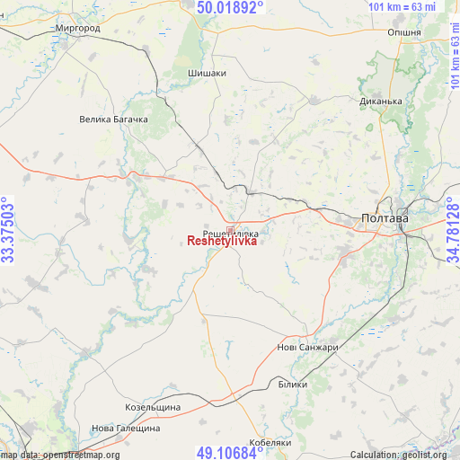
Reshetylivka GPS coordinates[2]
49° 33' 54.036" North, 34° 4' 41.34" East
| Map corner | latitude | longitude |
|---|---|---|
| Upper-left | 50.01892°, | 33.37503° |
| Center: | 49.56501°, | 34.07815° |
| Lower-right: | 49.10684°, | 34.78128° |
| Map W x H: | 101.4×101.4 km | = 63×63mi |
| max Lat: | 52.18903° ⇑24.2% North |
| Reshetylivka: | 49.56501° |
| min Lat: | ⇓75.8% South 44.39214° |
| min Long | Reshetylivka | max Long |
| 22.20555° | 34.07815° | 40.13222° |
| W 64.9%⇐ | ⇒35.1% E |
Elevation
Elevation of Reshetylivka is 90 m = 295 ft, and this is 65.8 m = 216 ft below average elevation for this country.
| Max E: |
886 m = 2907 ft | 65.1% |
| Avg. | 155.8 m = 511 ft | |
| Reshetylivka | 90 m = 295 ft | |
Min E: |
-3 m = -10 ft | 34.9% |
See also: Ukraine elevation on elevation.city.
Geographical zone
Reshetylivka is located in North temperate zone (between Tropic of Cancer and the Arctic Circle). Distance of this North polar circle is 1890.1 km =1174.5 mi to North.| Distance of | km | miles | from Reshetylivka |
|---|---|---|---|
| North Pole | 4495.9 | 2793.6 | to North |
| Arctic Circle | 1890.1 | 1174.5 | to North |
| Tropic Cancer | 2905.2 | 1805.2 | to South |
| Equator | 5511.1 | 3424.4 | to South |


Nearby cities:
15 places around Reshetylivka: (largest is in red/bold)
• Dykan’ka
43.4 km =27 mi,  48°
48°
• Hlobyne
62.3 km =38.7 mi,  251°
251°
• Khorol
62.5 km =38.8 mi,  292°
292°
• Kobelyaky
47.1 km =29.3 mi,  169°
169°
• Kozel’shchyna
42.1 km =26.2 mi,  203°
203°
• Lutovynivka
38.5 km =23.9 mi, 198°
• Mashivka
58.5 km =36.4 mi,  103°
103°
• Myrhorod
56.1 km =34.9 mi,  323°
323°
• Novi Sanzhary
29.8 km =18.5 mi,  145°
145°
• Oposhnya
58 km =36 mi,  41°
41°
• Poltava
33.5 km =20.8 mi,  84°
84°
• Semenivka
64.8 km =40.3 mi,  272°
272°
• Shyshaky
35.5 km =22.1 mi,  352°
352°
• Velyka Bahachka
35.9 km =22.3 mi,  314°
314°
• Velyki Sorochyntsi
51.9 km =32.2 mi, 349°
Sources, notices
• [Note1] Compared only with cities in Ukraine existing in our database
• [Src1] Map data: © OpenStreetMap contributors (CC-BY-SA)
• [Src2] Other city data from geonames.org with taken over terms of usage.
• [Src3] Geographical zone / Annual Mean Temperature by Robert A. Rohde @ Wikipedia
