Velyka Bahachka geodata
Velyka Bahachka (Poltava) is a seat of a second-order administrative division; located in Ukraine in Europe/Kiev (GMT+3) time zone. With population of 5,707 people, there are 589 cities with bigger population in this country. Compared to other cities in Ukraine, 79.3% of cities are located further ↓South; 56% of cities are located further ←West and 64.7% of cities have higher elevation than Velyka Bahachka. Note1


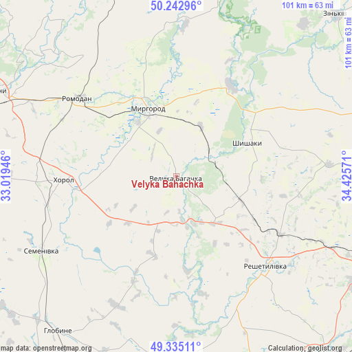
Velyka Bahachka GPS coordinates[2]
49° 47' 28.176" North, 33° 43' 21.288" East
| Map corner | latitude | longitude |
|---|---|---|
| Upper-left | 50.24296°, | 33.01946° |
| Center: | 49.79116°, | 33.72258° |
| Lower-right: | 49.33511°, | 34.42571° |
| Map W x H: | 100.9×100.9 km | = 62.7×62.7mi |
| max Lat: | 52.18903° ⇑20.7% North |
| Velyka Bahachka: | 49.79116° |
| min Lat: | ⇓79.3% South 44.39214° |
| min Long | Velyka Bahachka | max Long |
| 22.20555° | 33.72258° | 40.13222° |
| W 56%⇐ | ⇒44% E |
Elevation
Elevation of Velyka Bahachka is 92 m = 302 ft, and this is 63.8 m = 209 ft below average elevation for this country.
| Max E: |
886 m = 2907 ft | 64.7% |
| Avg. | 155.8 m = 511 ft | |
| Velyka Bahachka | 92 m = 302 ft | |
Min E: |
-3 m = -10 ft | 35.3% |
See also: Ukraine elevation on elevation.city.
Geographical zone
Velyka Bahachka is located in North temperate zone (between Tropic of Cancer and the Arctic Circle). Distance of this North polar circle is 1864.9 km =1158.8 mi to North.| Distance of | km | miles | from Velyka Bahachka |
|---|---|---|---|
| North Pole | 4470.8 | 2778 | to North |
| Arctic Circle | 1864.9 | 1158.8 | to North |
| Tropic Cancer | 2930.3 | 1820.8 | to South |
| Equator | 5536.3 | 3440.1 | to South |


Nearby cities:
15 places around Velyka Bahachka: (largest is in red/bold)
• Dykan’ka
57.9 km =36 mi,  86°
86°
• Hlobyne
55.9 km =34.7 mi,  216°
216°
• Khorol
31.9 km =19.8 mi,  268°
268°
• Komyshnya
43.7 km =27.2 mi,  356°
356°
• Kozel’shchyna
64.5 km =40.1 mi,  171°
171°
• Lubny
57.7 km =35.9 mi,  295°
295°
• Lutovynivka
63 km =39.1 mi, 167°
• Myrhorod
21.3 km =13.2 mi,  337°
337°
• Poltava
62.8 km =39 mi,  110°
110°
• Reshetylivka
35.9 km =22.3 mi,  134°
134°
• Romodan
36.1 km =22.4 mi,  307°
307°
• Semenivka
44.9 km =27.9 mi,  240°
240°
• Sencha
58.2 km =36.2 mi,  332°
332°
• Shyshaky
23 km =14.3 mi,  64°
64°
• Velyki Sorochyntsi
30.2 km =18.8 mi,  31°
31°
Sources, notices
• [Note1] Compared only with cities in Ukraine existing in our database
• [Src1] Map data: © OpenStreetMap contributors (CC-BY-SA)
• [Src2] Other city data from geonames.org with taken over terms of usage.
• [Src3] Geographical zone / Annual Mean Temperature by Robert A. Rohde @ Wikipedia
