Lokhvytsya geodata
Lokhvytsya (Poltava) is a seat of a second-order administrative division; located in Ukraine in Europe/Kiev (GMT+3) time zone. With population of 11,950 people, there are 310 cities with bigger population in this country. Compared to other cities in Ukraine, 89.1% of cities are located further ↓South; 50.8% of cities are located further →East and 60.6% of cities have higher elevation than Lokhvytsya. Note1


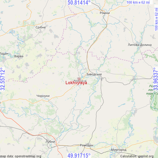
Lokhvytsya GPS coordinates[2]
50° 22' 3.936" North, 33° 15' 36.864" East
| Map corner | latitude | longitude |
|---|---|---|
| Upper-left | 50.81414°, | 32.55712° |
| Center: | 50.36776°, | 33.26024° |
| Lower-right: | 49.91715°, | 33.96337° |
| Map W x H: | 99.7×99.7 km | = 62×62mi |
| max Lat: | 52.18903° ⇑10.9% North |
| Lokhvytsya: | 50.36776° |
| min Lat: | ⇓89.1% South 44.39214° |
| min Long | Lokhvytsya | max Long |
| 22.20555° | 33.26024° | 40.13222° |
| W 49.2%⇐ | ⇒50.8% E |
Elevation
Elevation of Lokhvytsya is 104 m = 341 ft, and this is 51.8 m = 170 ft below average elevation for this country.
| Max E: |
886 m = 2907 ft | 60.6% |
| Avg. | 155.8 m = 511 ft | |
| Lokhvytsya | 104 m = 341 ft | |
Min E: |
-3 m = -10 ft | 39.4% |
See also: Ukraine elevation on elevation.city.
Geographical zone
Lokhvytsya is located in North temperate zone (between Tropic of Cancer and the Arctic Circle). Distance of this North polar circle is 1800.8 km =1119 mi to North.| Distance of | km | miles | from Lokhvytsya |
|---|---|---|---|
| North Pole | 4406.7 | 2738.2 | to North |
| Arctic Circle | 1800.8 | 1119 | to North |
| Tropic Cancer | 2994.5 | 1860.7 | to South |
| Equator | 5600.4 | 3479.9 | to South |


Nearby cities:
15 places around Lokhvytsya: (largest is in red/bold)
• Chornukhy
25.2 km =15.7 mi,  243°
243°
• Dihtyari
42.1 km =26.2 mi,  304°
304°
• Hadyach
51.8 km =32.2 mi,  89°
89°
• Komyshnya
36.3 km =22.6 mi,  124°
124°
• Ladan
50.9 km =31.6 mi,  289°
289°
• Lubny
43.3 km =26.9 mi,  205°
205°
• Lypova Dolyna
43.9 km =27.3 mi,  60°
60°
• Myrhorod
50.9 km =31.6 mi,  150°
150°
• Romny
45.2 km =28.1 mi,  19°
19°
• Romodan
42.2 km =26.2 mi,  173°
173°
• Sencha
14 km =8.7 mi, 154°
• Sribne
40.8 km =25.4 mi,  323°
323°
• Talalayivka
53.1 km =33 mi,  351°
351°
• Varva
40.8 km =25.4 mi, 290°
• Zhuravka
48.8 km =30.3 mi,  284°
284°
Sources, notices
• [Note1] Compared only with cities in Ukraine existing in our database
• [Src1] Map data: © OpenStreetMap contributors (CC-BY-SA)
• [Src2] Other city data from geonames.org with taken over terms of usage.
• [Src3] Geographical zone / Annual Mean Temperature by Robert A. Rohde @ Wikipedia
