Romny geodata
Romny (Sumy) is a seat of a second-order administrative division; located in Ukraine in Europe/Kiev (GMT+3) time zone. With population of 48,570 people, there are 100 cities with bigger population in this country. Compared to other cities in Ukraine, 93.8% of cities are located further ↓South; 51.4% of cities are located further ←West and 56.6% of cities have lower elevation than Romny. Note1


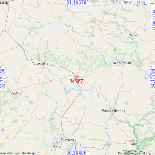
Romny GPS coordinates[2]
50° 45' 3.744" North, 33° 28' 28.956" East
| Map corner | latitude | longitude |
|---|---|---|
| Upper-left | 51.19379°, | 32.77159° |
| Center: | 50.75104°, | 33.47471° |
| Lower-right: | 50.30406°, | 34.17784° |
| Map W x H: | 98.9×98.9 km | = 61.5×61.5mi |
| max Lat: | 52.18903° ⇑6.2% North |
| Romny: | 50.75104° |
| min Lat: | ⇓93.8% South 44.39214° |
| min Long | Romny | max Long |
| 22.20555° | 33.47471° | 40.13222° |
| W 51.4%⇐ | ⇒48.6% E |
Elevation
Elevation of Romny is 157 m = 515 ft, and this is 1.2 m = 4 ft above average elevation for this country.
| Max E: |
886 m = 2907 ft | 43.4% |
| Romny | 157 m 515 ft | |
| Avg. | 155.8 m = 511 ft | |
Min E: |
-3 m = -10 ft | 56.6% |
See also: Romny elevation on elevation.city.
Geographical zone
Romny is located in North temperate zone (between Tropic of Cancer and the Arctic Circle). Distance of this North polar circle is 1758.2 km =1092.5 mi to North.| Distance of | km | miles | from Romny |
|---|---|---|---|
| North Pole | 4364.1 | 2711.7 | to North |
| Arctic Circle | 1758.2 | 1092.5 | to North |
| Tropic Cancer | 3037.1 | 1887.2 | to South |
| Equator | 5643 | 3506.4 | to South |


Nearby cities:
15 places around Romny: (largest is in red/bold)
• Bakhmach
65.6 km =40.8 mi,  316°
316°
• Buryn’
55.9 km =34.7 mi,  26°
26°
• Dihtyari
53.1 km =33 mi,  249°
249°
• Hadyach
55.8 km =34.7 mi,  139°
139°
• Komyshnya
64.8 km =40.3 mi,  166°
166°
• Konotop
57.6 km =35.8 mi,  340°
340°
• Lokhvytsya
45.2 km =28.1 mi,  199°
199°
• Lypova Dolyna
30.8 km =19.1 mi,  132°
132°
• Nedryhayliv
29.7 km =18.5 mi,  71°
71°
• Sencha
55.9 km =34.7 mi,  189°
189°
• Sloboda
50.6 km =31.4 mi,  10°
10°
• Sribne
40.3 km =25 mi,  256°
256°
• Talalayivka
25.2 km =15.7 mi,  292°
292°
• Terny
43.7 km =27.2 mi,  52°
52°
• Varva
60.4 km =37.5 mi,  241°
241°
Sources, notices
• [Note1] Compared only with cities in Ukraine existing in our database
• [Src1] Map data: © OpenStreetMap contributors (CC-BY-SA)
• [Src2] Other city data from geonames.org with taken over terms of usage.
• [Src3] Geographical zone / Annual Mean Temperature by Robert A. Rohde @ Wikipedia
