Castillos geodata
Castillos (Rocha) is a populated place; located in Uruguay in America/Montevideo (GMT-3) time zone. With population of 7,686 people, there are 42 cities with bigger population in this country. Compared to other cities in Uruguay, 54.1% of cities are located further ↑North; 96.7% of cities are located further ←West and 67.2% of cities have higher elevation than Castillos. Note1


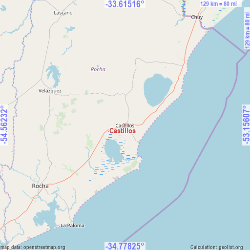
Castillos GPS coordinates[2]
34° 11' 55.356" South, 53° 51' 33.084" West
| Map corner | latitude | longitude |
|---|---|---|
| Upper-left | -33.61516°, | -54.56232° |
| Center: | -34.19871°, | -53.85919° |
| Lower-right: | -34.77825°, | -53.15607° |
| Map W x H: | 129.3×129.3 km | = 80.3×80.3mi |
| max Lat: | -30.25966° ⇑54.1% North |
| Castillos: | -34.19871° |
| min Lat: | ⇓45.9% South -34.94747° |
| min Long | Castillos | max Long |
| -58.41176° | -53.85919° | -53.38583° |
| W 96.7%⇐ | ⇒3.3% E |
Elevation
Elevation of Castillos is 33 m = 108 ft, and this is 37.6 m = 123 ft below average elevation for this country.
| Max E: |
294 m = 965 ft | 67.2% |
| Avg. | 70.6 m = 232 ft | |
| Castillos | 33 m = 108 ft | |
Min E: |
2 m = 7 ft | 32.8% |
See also: Uruguay elevation on elevation.city.
Geographical zone
Castillos is located in South temperate zone (between Tropic of Capricorn and the Antarctic Circle). Distance of this Southern Tropic circle is 1196.6 km =743.5 mi to North.| Distance of | km | miles | from Castillos |
|---|---|---|---|
| Equator | 3802.5 | 2362.8 | to North |
| Tropic Capricorn | 1196.6 | 743.5 | to North |
| Antarctic Circle | 3598.6 | 2236.1 | to South |
| South Pole | 6204.5 | 3855.3 | to South |


Nearby cities:
15 places around Castillos: (largest is in red/bold)
• Aiguá
82.5 km =51.3 mi,  269°
269°
• Cebollatí
103.8 km =64.5 mi,  3°
3°
• Chui
66.8 km =41.5 mi,  33°
33°
• Dieciocho de Julio
64 km =39.8 mi, 26°
• José Pedro Varela
103.7 km =64.4 mi,  322°
322°
• La Paloma
58.7 km =36.5 mi,  208°
208°
• Lascano
66.7 km =41.4 mi,  331°
331°
• Maldonado
126.7 km =78.7 mi,  232°
232°
• Mariscala
86.3 km =53.6 mi,  281°
281°
• Minas
128.2 km =79.7 mi,  261°
261°
• Rocha
53.8 km =33.4 mi, 233°
• San Carlos
117.3 km =72.9 mi,  235°
235°
• Treinta y Tres
117.8 km =73.2 mi,  335°
335°
• Velázquez
42.8 km =26.6 mi,  294°
294°
• Villa Sara
117.2 km =72.8 mi, 333°
Sources, notices
• [Note1] Compared only with cities in Uruguay existing in our database
• [Src1] Map data: © OpenStreetMap contributors (CC-BY-SA)
• [Src2] Other city data from geonames.org with taken over terms of usage.
• [Src3] Geographical zone / Annual Mean Temperature by Robert A. Rohde @ Wikipedia
