Ḩawf geodata
Ḩawf (Al Mahrah) is a seat of a second-order administrative division; located in Yemen in Asia/Aden (GMT+3) time zone. In our database, there are 51 cities with bigger population. Compared to other cities in Yemen, 92.5% of cities are located further ↓South; 99.4% of cities are located further ←West and 93.8% of cities have higher elevation than Ḩawf. Note1


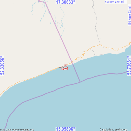
Ḩawf GPS coordinates[2]
16° 38' 1.788" North, 53° 2' 1.248" East
| Map corner | latitude | longitude |
|---|---|---|
| Upper-left | 17.30633°, | 52.33056° |
| Center: | 16.63383°, | 53.03368° |
| Lower-right: | 15.95896°, | 53.73681° |
| Map W x H: | 149.8×149.8 km | = 93.1×93.1mi |
| max Lat: | 17.76999° ⇑7.5% North |
| Ḩawf: | 16.63383° |
| min Lat: | ⇓92.5% South 12.18576° |
| min Long | Ḩawf | max Long |
| 42.67107° | 53.03368° | 54.01895° |
| W 99.4%⇐ | ⇒0.59999999999999% E |
Elevation
Elevation of Ḩawf is 17 m = 56 ft, and this is 1287.8 m = 4225 ft below average elevation for this country.
| Max E: |
2791 m = 9157 ft | 93.8% |
| Avg. | 1304.8 m = 4281 ft | |
| Ḩawf | 17 m = 56 ft | |
Min E: |
4 m = 13 ft | 6.2% |
See also: Yemen elevation on elevation.city.
Geographical zone
Ḩawf is located in North Torrid zone (between Equator and Tropic of Cancer). Distance of this Northern Tropic circle is 756.4 km =470 mi to North.| Distance of | km | miles | from Ḩawf |
|---|---|---|---|
| North Pole | 8157.6 | 5068.9 | to North |
| Arctic Circle | 5551.7 | 3449.7 | to North |
| Tropic Cancer | 756.4 | 470 | to North |
| Equator | 1849.5 | 1149.2 | to South |


Nearby cities:
15 places around Ḩawf: (largest is in red/bold)
• Ad Dīs ash Sharqīyah
381.8 km =237.2 mi,  239°
239°
• Al Bilād
403 km =250.4 mi,  262°
262°
• Al Ghayz̧ah
103 km =64 mi, 242°
• Al Qurḩ
165.5 km =102.8 mi,  273°
273°
• Ar Raydah
326 km =202.6 mi, 236°
• Ash Shiḩr
422 km =262.2 mi, 240°
• Bi’r Ḩāt
125.7 km =78.1 mi,  307°
307°
• Daḩasuways
266 km =165.3 mi,  247°
247°
• Qalansīyah
441.3 km =274.2 mi,  173°
173°
• Qishn
197.7 km =122.8 mi,  227°
227°
• Rumāh
276.6 km =171.9 mi,  289°
289°
• Sayḩūt
248.2 km =154.2 mi, 230°
• Shiḩan as Suflá
138.9 km =86.3 mi,  335°
335°
• Thamūd
339.2 km =210.8 mi,  282°
282°
• Ḩaşwayn
152.9 km =95 mi,  220°
220°
Sources, notices
• [Note1] Compared only with cities in Yemen existing in our database
• [Src1] Map data: © OpenStreetMap contributors (CC-BY-SA)
• [Src2] Other city data from geonames.org with taken over terms of usage.
• [Src3] Geographical zone / Annual Mean Temperature by Robert A. Rohde @ Wikipedia
