Musina geodata
Musina (Limpopo) is a seat of a third-order administrative division; located in South Africa in Africa/Johannesburg (GMT+2) time zone. In our database, there are 257 cities with bigger population. Compared to other cities in South Africa, 100% of cities are located further ↓South; 80.8% of cities are located further ←West and 74% of cities have higher elevation than Musina. Note1


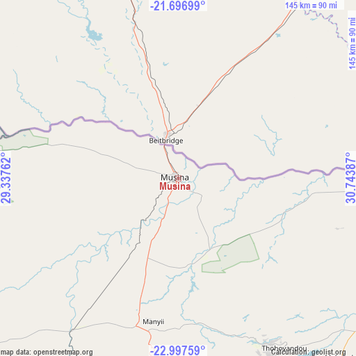
Musina GPS coordinates[2]
22° 20' 55.716" South, 30° 2' 26.664" East
| Map corner | latitude | longitude |
|---|---|---|
| Upper-left | -21.69699°, | 29.33762° |
| Center: | -22.34881°, | 30.04074° |
| Lower-right: | -22.99759°, | 30.74387° |
| Map W x H: | 144.6×144.6 km | = 89.9×89.9mi |
| max Lat: | -22.34881° ⇑0% North |
| Musina: | -22.34881° |
| min Lat: | ⇓100% South -34.66739° |
| min Long | Musina | max Long |
| 16.8697° | 30.04074° | 32.26762° |
| W 80.8%⇐ | ⇒19.2% E |
Elevation
Elevation of Musina is 540 m = 1772 ft, and this is 429.6 m = 1409 ft below average elevation for this country.
| Max E: |
1873 m = 6145 ft | 74% |
| Avg. | 969.6 m = 3181 ft | |
| Musina | 540 m = 1772 ft | |
Min E: |
7 m = 23 ft | 26% |
See also: South Africa elevation on elevation.city.
Geographical zone
Musina is located in South Torrid zone (between Equator and Tropic of Capricorn). Distance of this Southern Tropic circle is 121 km =75.2 mi to South.| Distance of | km | miles | from Musina |
|---|---|---|---|
| Equator | 2485 | 1544.1 | to North |
| Tropic Capricorn | 121 | 75.2 | to South |
| Antarctic Circle | 4916.2 | 3054.8 | to South |
| South Pole | 7522.1 | 4674 | to South |


Nearby cities:
15 places around Musina: (largest is in red/bold)
• Bochum
139.2 km =86.5 mi,  221°
221°
• Dendron
134.9 km =83.8 mi,  212°
212°
• Duiwelskloof
149.8 km =93.1 mi,  176°
176°
• Ga-Kgapane
145.2 km =90.2 mi,  172°
172°
• Giyani
126.8 km =78.8 mi,  146°
146°
• Lebowakgomo
213.1 km =132.4 mi,  195°
195°
• Louis Trichardt
78.6 km =48.8 mi,  190°
190°
• Mankoeng
174 km =108.1 mi, 187°
• Mokopane
230.6 km =143.3 mi, 207°
• Mutale
86.8 km =53.9 mi,  98°
98°
• Nkowakowa
173 km =107.5 mi, 171°
• Phalaborwa
209.9 km =130.4 mi, 147°
• Polokwane
182.6 km =113.5 mi, 198°
• Thohoyandou
80.5 km =50 mi, 145°
• Tzaneen
165.5 km =102.8 mi, 175°
Sources, notices
• [Note1] Compared only with cities in South Africa existing in our database
• [Src1] Map data: © OpenStreetMap contributors (CC-BY-SA)
• [Src2] Other city data from geonames.org with taken over terms of usage.
• [Src3] Geographical zone / Annual Mean Temperature by Robert A. Rohde @ Wikipedia
