Thohoyandou geodata
Thohoyandou (Limpopo) is a seat of a second-order administrative division; located in South Africa in Africa/Johannesburg (GMT+2) time zone. With population of 44,046 people, there are 100 cities with bigger population in this country. Compared to other cities in South Africa, 99.4% of cities are located further ↓South; 87.6% of cities are located further ←West and 68.7% of cities have higher elevation than Thohoyandou. Note1
Administrative division(s):
- Level 1: Limpopo
- Level 2: Vhembe District Municipality
- Level 3: Thulamela


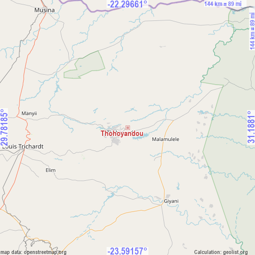
Thohoyandou GPS coordinates[2]
22° 56' 44.304" South, 30° 29' 5.892" East
| Map corner | latitude | longitude |
|---|---|---|
| Upper-left | -22.29661°, | 29.78185° |
| Center: | -22.94564°, | 30.48497° |
| Lower-right: | -23.59157°, | 31.1881° |
| Map W x H: | 144×144 km | = 89.5×89.5mi |
| max Lat: | -22.34881° ⇑0.6% North |
| Thohoyandou: | -22.94564° |
| min Lat: | ⇓99.4% South -34.66739° |
| min Long | Thohoyandou | max Long |
| 16.8697° | 30.48497° | 32.26762° |
| W 87.6%⇐ | ⇒12.4% E |
Elevation
Elevation of Thohoyandou is 724 m = 2375 ft, and this is 245.6 m = 806 ft below average elevation for this country.
| Max E: |
1873 m = 6145 ft | 68.7% |
| Avg. | 969.6 m = 3181 ft | |
| Thohoyandou | 724 m = 2375 ft | |
Min E: |
7 m = 23 ft | 31.3% |
See also: Thohoyandou elevation on elevation.city.
Geographical zone
Thohoyandou is located in South Torrid zone (between Equator and Tropic of Capricorn). Distance of this Southern Tropic circle is 54.6 km =33.9 mi to South.| Distance of | km | miles | from Thohoyandou |
|---|---|---|---|
| Equator | 2551.3 | 1585.3 | to North |
| Tropic Capricorn | 54.6 | 33.9 | to South |
| Antarctic Circle | 4849.9 | 3013.6 | to South |
| South Pole | 7455.7 | 4632.8 | to South |


Nearby cities:
15 places around Thohoyandou: (largest is in red/bold)
• Bochum
142.7 km =88.7 mi,  254°
254°
• Dendron
127.6 km =79.3 mi, 248°
• Duiwelskloof
90.3 km =56.1 mi,  202°
202°
• Ga-Kgapane
82.1 km =51 mi, 199°
• Giyani
46.3 km =28.8 mi,  148°
148°
• Hoedspruit
163.4 km =101.5 mi,  163°
163°
• Lebowakgomo
171.8 km =106.8 mi,  215°
215°
• Louis Trichardt
60.5 km =37.6 mi,  259°
259°
• Mankoeng
126.1 km =78.4 mi,  212°
212°
• Musina
80.5 km =50 mi,  325°
325°
• Mutale
66.4 km =41.3 mi,  37°
37°
• Nkowakowa
106.7 km =66.3 mi,  190°
190°
• Phalaborwa
129.5 km =80.5 mi, 148°
• Polokwane
148.7 km =92.4 mi, 224°
• Tzaneen
104 km =64.6 mi, 198°
Sources, notices
• [Note1] Compared only with cities in South Africa existing in our database
• [Src1] Map data: © OpenStreetMap contributors (CC-BY-SA)
• [Src2] Other city data from geonames.org with taken over terms of usage.
• [Src3] Geographical zone / Annual Mean Temperature by Robert A. Rohde @ Wikipedia
