Giyani geodata
Giyani (Limpopo) is a seat of a second-order administrative division; located in South Africa in Africa/Johannesburg (GMT+2) time zone. With population of 37,024 people, there are 109 cities with bigger population in this country. Compared to other cities in South Africa, 98.5% of cities are located further ↓South; 89.4% of cities are located further ←West and 76.7% of cities have higher elevation than Giyani. Note1
Administrative division(s):
- Level 1: Limpopo
- Level 2: Mopani District Municipality
- Level 3: Greater Giyani


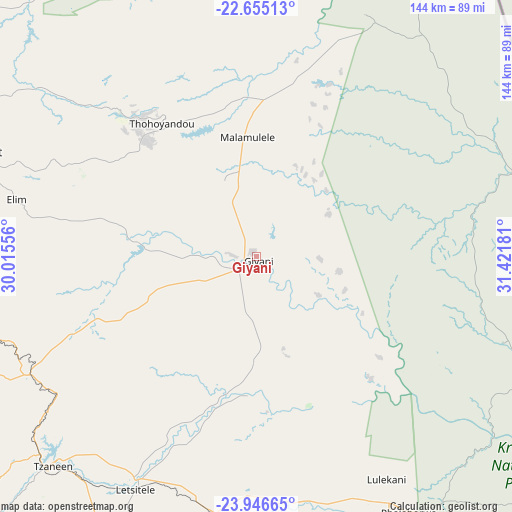
Giyani GPS coordinates[2]
23° 18' 8.856" South, 30° 43' 7.248" East
| Map corner | latitude | longitude |
|---|---|---|
| Upper-left | -22.65513°, | 30.01556° |
| Center: | -23.30246°, | 30.71868° |
| Lower-right: | -23.94665°, | 31.42181° |
| Map W x H: | 143.6×143.6 km | = 89.2×89.2mi |
| max Lat: | -22.34881° ⇑1.5% North |
| Giyani: | -23.30246° |
| min Lat: | ⇓98.5% South -34.66739° |
| min Long | Giyani | max Long |
| 16.8697° | 30.71868° | 32.26762° |
| W 89.4%⇐ | ⇒10.6% E |
Elevation
Elevation of Giyani is 484 m = 1588 ft, and this is 485.6 m = 1593 ft below average elevation for this country.
| Max E: |
1873 m = 6145 ft | 76.7% |
| Avg. | 969.6 m = 3181 ft | |
| Giyani | 484 m = 1588 ft | |
Min E: |
7 m = 23 ft | 23.3% |
See also: South Africa elevation on elevation.city.
Geographical zone
Giyani is located in South Torrid zone (between Equator and Tropic of Capricorn). Distance of this Southern Tropic circle is 14.9 km =9.3 mi to South.| Distance of | km | miles | from Giyani |
|---|---|---|---|
| Equator | 2591 | 1610 | to North |
| Tropic Capricorn | 14.9 | 9.3 | to South |
| Antarctic Circle | 4810.2 | 2988.9 | to South |
| South Pole | 7416.1 | 4608.1 | to South |


Nearby cities:
15 places around Giyani: (largest is in red/bold)
• Apel
158.1 km =98.2 mi,  218°
218°
• Burgersfort
157.7 km =98 mi,  194°
194°
• Dendron
142.6 km =88.6 mi,  267°
267°
• Duiwelskloof
73.3 km =45.5 mi,  233°
233°
• Ga-Kgapane
63.2 km =39.3 mi, 233°
• Hoedspruit
119 km =73.9 mi,  168°
168°
• Louis Trichardt
88.2 km =54.8 mi,  289°
289°
• Mankoeng
113.4 km =70.5 mi, 234°
• Musina
126.8 km =78.8 mi,  326°
326°
• Mutale
94 km =58.4 mi,  9°
9°
• Nkowakowa
78.6 km =48.8 mi,  214°
214°
• Phalaborwa
83.2 km =51.7 mi,  148°
148°
• Polokwane
143.9 km =89.4 mi,  242°
242°
• Thohoyandou
46.3 km =28.8 mi, 328°
• Tzaneen
81.8 km =50.8 mi, 223°
Sources, notices
• [Note1] Compared only with cities in South Africa existing in our database
• [Src1] Map data: © OpenStreetMap contributors (CC-BY-SA)
• [Src2] Other city data from geonames.org with taken over terms of usage.
• [Src3] Geographical zone / Annual Mean Temperature by Robert A. Rohde @ Wikipedia
