Shangani geodata
Shangani (Midlands) is a populated place; located in Zimbabwe in Africa/Harare (GMT+2) time zone. With population of 3,835 people, there are 46 cities with bigger population in this country. Compared to other cities in Zimbabwe, 81.5% of cities are located further ↑North; 75.4% of cities are located further →East and 72.3% of cities have lower elevation than Shangani. Note1


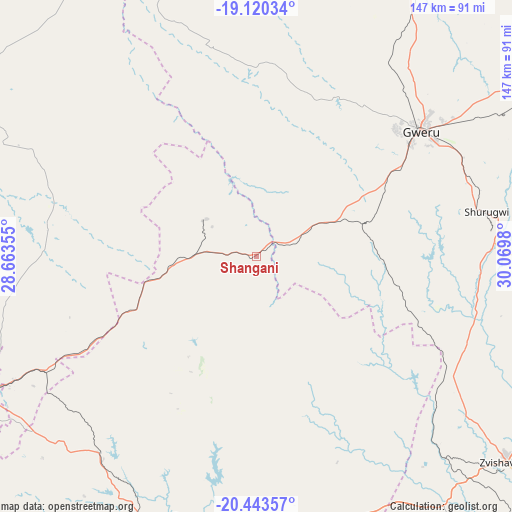
Shangani GPS coordinates[2]
19° 46' 59.988" South, 29° 22' 0.012" East
| Map corner | latitude | longitude |
|---|---|---|
| Upper-left | -19.12034°, | 28.66355° |
| Center: | -19.78333°, | 29.36667° |
| Lower-right: | -20.44357°, | 30.0698° |
| Map W x H: | 147.1×147.1 km | = 91.4×91.4mi |
| max Lat: | -16.03333° ⇑81.5% North |
| Shangani: | -19.78333° |
| min Lat: | ⇓18.5% South -22.21667° |
| min Long | Shangani | max Long |
| 25.83066° | 29.36667° | 32.86667° |
| W 24.6%⇐ | ⇒75.4% E |
Elevation
Elevation of Shangani is 1377 m = 4518 ft, and this is 179.3 m = 588 ft above average elevation for this country.
| Max E: |
1706 m = 5597 ft | 27.7% |
| Shangani | 1377 m 4518 ft | |
| Avg. | 1197.7 m = 3929 ft | |
Min E: |
402 m = 1319 ft | 72.3% |
See also: Zimbabwe elevation on elevation.city.
Geographical zone
Shangani is located in South Torrid zone (between Equator and Tropic of Capricorn). Distance of this Southern Tropic circle is 406.2 km =252.4 mi to South.| Distance of | km | miles | from Shangani |
|---|---|---|---|
| Equator | 2199.7 | 1366.8 | to North |
| Tropic Capricorn | 406.2 | 252.4 | to South |
| Antarctic Circle | 5201.5 | 3232.1 | to South |
| South Pole | 7807.4 | 4851.3 | to South |


Nearby cities:
15 places around Shangani: (largest is in red/bold)
• Bulawayo
91.5 km =56.9 mi,  243°
243°
• Esigodini
73 km =45.4 mi,  219°
219°
• Filabusi
83.8 km =52.1 mi,  185°
185°
• Gwanda
133.6 km =83 mi,  196°
196°
• Gweru
60 km =37.3 mi,  51°
51°
• Insiza
17.4 km =10.8 mi,  270°
270°
• Inyati
55.7 km =34.6 mi,  282°
282°
• Kwekwe
106.1 km =65.9 mi,  26°
26°
• Lalapanzi
98.7 km =61.3 mi,  59°
59°
• Mashava
120 km =74.6 mi,  103°
103°
• Masvingo
155.9 km =96.9 mi, 101°
• Mvuma
134 km =83.3 mi,  65°
65°
• Redcliff
94.1 km =58.5 mi, 27°
• Shurugwi
68.1 km =42.3 mi,  79°
79°
• Zvishavane
94.8 km =58.9 mi,  129°
129°
Sources, notices
• [Note1] Compared only with cities in Zimbabwe existing in our database
• [Src1] Map data: © OpenStreetMap contributors (CC-BY-SA)
• [Src2] Other city data from geonames.org with taken over terms of usage.
• [Src3] Geographical zone / Annual Mean Temperature by Robert A. Rohde @ Wikipedia
