Redcliff geodata
Redcliff (Midlands) is a populated place; located in Zimbabwe in Africa/Harare (GMT+2) time zone. With population of 33,197 people, there are 17 cities with bigger population in this country. Compared to other cities in Zimbabwe, 69.2% of cities are located further ↑North; 72.3% of cities are located further →East and 50.8% of cities have lower elevation than Redcliff. Note1


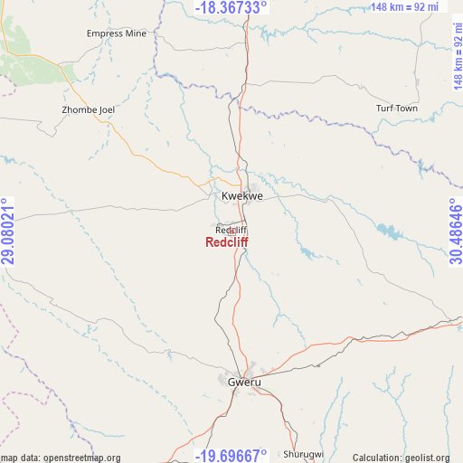
Redcliff GPS coordinates[2]
19° 1' 59.988" South, 29° 46' 59.988" East
| Map corner | latitude | longitude |
|---|---|---|
| Upper-left | -18.36733°, | 29.08021° |
| Center: | -19.03333°, | 29.78333° |
| Lower-right: | -19.69667°, | 30.48646° |
| Map W x H: | 147.8×147.8 km | = 91.8×91.8mi |
| max Lat: | -16.03333° ⇑69.2% North |
| Redcliff: | -19.03333° |
| min Lat: | ⇓30.8% South -22.21667° |
| min Long | Redcliff | max Long |
| 25.83066° | 29.78333° | 32.86667° |
| W 27.7%⇐ | ⇒72.3% E |
Elevation
Elevation of Redcliff is 1232 m = 4042 ft, and this is 34.3 m = 113 ft above average elevation for this country.
| Max E: |
1706 m = 5597 ft | 49.2% |
| Redcliff | 1232 m 4042 ft | |
| Avg. | 1197.7 m = 3929 ft | |
Min E: |
402 m = 1319 ft | 50.8% |
See also: Zimbabwe elevation on elevation.city.
Geographical zone
Redcliff is located in South Torrid zone (between Equator and Tropic of Capricorn). Distance of this Southern Tropic circle is 489.6 km =304.2 mi to South.| Distance of | km | miles | from Redcliff |
|---|---|---|---|
| Equator | 2116.3 | 1315 | to North |
| Tropic Capricorn | 489.6 | 304.2 | to South |
| Antarctic Circle | 5284.9 | 3283.9 | to South |
| South Pole | 7890.8 | 4903.1 | to South |


Nearby cities:
15 places around Redcliff: (largest is in red/bold)
• Beatrice
141.8 km =88.1 mi,  52°
52°
• Chakari
108.5 km =67.4 mi,  6°
6°
• Chegutu
107.3 km =66.7 mi,  20°
20°
• Chivhu
116.6 km =72.5 mi,  89°
89°
• Gokwe
128.4 km =79.8 mi,  315°
315°
• Gweru
46.5 km =28.9 mi,  175°
175°
• Insiza
103.4 km =64.2 mi,  216°
216°
• Inyati
121.5 km =75.5 mi,  233°
233°
• Kadoma
79.1 km =49.2 mi, 10°
• Kwekwe
12.2 km =7.6 mi, 15°
• Lalapanzi
53.1 km =33 mi,  128°
128°
• Mashava
133.5 km =83 mi,  146°
146°
• Mvuma
82.9 km =51.5 mi,  109°
109°
• Shangani
94.1 km =58.5 mi,  207°
207°
• Shurugwi
74.6 km =46.4 mi,  161°
161°
Sources, notices
• [Note1] Compared only with cities in Zimbabwe existing in our database
• [Src1] Map data: © OpenStreetMap contributors (CC-BY-SA)
• [Src2] Other city data from geonames.org with taken over terms of usage.
• [Src3] Geographical zone / Annual Mean Temperature by Robert A. Rohde @ Wikipedia
