Esigodini geodata
Esigodini (Matabeleland South) is a populated place; located in Zimbabwe in Africa/Harare (GMT+2) time zone. With population of 2,228 people, there are 53 cities with bigger population in this country. Compared to other cities in Zimbabwe, 90.8% of cities are located further ↑North; 83.1% of cities are located further →East and 56.9% of cities have higher elevation than Esigodini. Note1


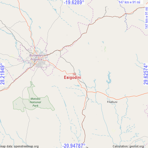
Esigodini GPS coordinates[2]
20° 17' 23.244" South, 28° 55' 21.396" East
| Map corner | latitude | longitude |
|---|---|---|
| Upper-left | -19.6289°, | 28.21949° |
| Center: | -20.28979°, | 28.92261° |
| Lower-right: | -20.94787°, | 29.62574° |
| Map W x H: | 146.7×146.7 km | = 91.2×91.2mi |
| max Lat: | -16.03333° ⇑90.8% North |
| Esigodini: | -20.28979° |
| min Lat: | ⇓9.2% South -22.21667° |
| min Long | Esigodini | max Long |
| 25.83066° | 28.92261° | 32.86667° |
| W 16.9%⇐ | ⇒83.1% E |
Elevation
Elevation of Esigodini is 1181 m = 3875 ft, and this is 16.7 m = 55 ft below average elevation for this country.
| Max E: |
1706 m = 5597 ft | 56.9% |
| Avg. | 1197.7 m = 3929 ft | |
| Esigodini | 1181 m = 3875 ft | |
Min E: |
402 m = 1319 ft | 43.1% |
See also: Zimbabwe elevation on elevation.city.
Geographical zone
Esigodini is located in South Torrid zone (between Equator and Tropic of Capricorn). Distance of this Southern Tropic circle is 349.9 km =217.4 mi to South.| Distance of | km | miles | from Esigodini |
|---|---|---|---|
| Equator | 2256 | 1401.8 | to North |
| Tropic Capricorn | 349.9 | 217.4 | to South |
| Antarctic Circle | 5145.2 | 3197.1 | to South |
| South Pole | 7751 | 4816.2 | to South |


Nearby cities:
15 places around Esigodini: (largest is in red/bold)
• Bulawayo
38.7 km =24 mi,  293°
293°
• Filabusi
46.5 km =28.9 mi,  125°
125°
• Gwanda
72.4 km =45 mi,  173°
173°
• Gweru
132.1 km =82.1 mi,  45°
45°
• Insiza
63.3 km =39.3 mi,  27°
27°
• Inyati
68.7 km =42.7 mi,  353°
353°
• Kwekwe
177.9 km =110.5 mi, 31°
• Lalapanzi
169 km =105 mi, 50°
• Lupane
191 km =118.7 mi,  322°
322°
• Mashava
165.2 km =102.7 mi,  80°
80°
• Plumtree
117.3 km =72.9 mi,  259°
259°
• Redcliff
166.3 km =103.3 mi, 32°
• Shangani
73 km =45.4 mi,  39°
39°
• Shurugwi
132.5 km =82.3 mi,  58°
58°
• Zvishavane
119.4 km =74.2 mi,  91°
91°
Sources, notices
• [Note1] Compared only with cities in Zimbabwe existing in our database
• [Src1] Map data: © OpenStreetMap contributors (CC-BY-SA)
• [Src2] Other city data from geonames.org with taken over terms of usage.
• [Src3] Geographical zone / Annual Mean Temperature by Robert A. Rohde @ Wikipedia
