Gweru geodata
Gweru (Midlands) is a seat of a first-order administrative division; located in Zimbabwe in Africa/Harare (GMT+2) time zone. With population of 146,073 people, there are 4 cities with bigger population in this country. Compared to other cities in Zimbabwe, 75.4% of cities are located further ↑North; 69.2% of cities are located further →East and 76.9% of cities have lower elevation than Gweru. Note1


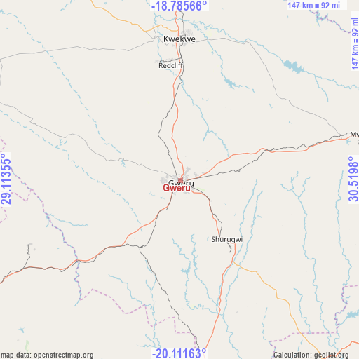
Gweru GPS coordinates[2]
19° 27' 0" South, 29° 49' 0.012" East
| Map corner | latitude | longitude |
|---|---|---|
| Upper-left | -18.78566°, | 29.11355° |
| Center: | -19.45°, | 29.81667° |
| Lower-right: | -20.11163°, | 30.5198° |
| Map W x H: | 147.4×147.4 km | = 91.6×91.6mi |
| max Lat: | -16.03333° ⇑75.4% North |
| Gweru: | -19.45° |
| min Lat: | ⇓24.6% South -22.21667° |
| min Long | Gweru | max Long |
| 25.83066° | 29.81667° | 32.86667° |
| W 30.8%⇐ | ⇒69.2% E |
Elevation
Elevation of Gweru is 1412 m = 4633 ft, and this is 214.3 m = 703 ft above average elevation for this country.
| Max E: |
1706 m = 5597 ft | 23.1% |
| Gweru | 1412 m 4633 ft | |
| Avg. | 1197.7 m = 3929 ft | |
Min E: |
402 m = 1319 ft | 76.9% |
See also: Gweru elevation on elevation.city.
Geographical zone
Gweru is located in South Torrid zone (between Equator and Tropic of Capricorn). Distance of this Southern Tropic circle is 443.3 km =275.5 mi to South.| Distance of | km | miles | from Gweru |
|---|---|---|---|
| Equator | 2162.6 | 1343.8 | to North |
| Tropic Capricorn | 443.3 | 275.5 | to South |
| Antarctic Circle | 5238.5 | 3255.1 | to South |
| South Pole | 7844.4 | 4874.3 | to South |


Nearby cities:
15 places around Gweru: (largest is in red/bold)
• Chivhu
122.6 km =76.2 mi,  67°
67°
• Esigodini
132.1 km =82.1 mi,  225°
225°
• Filabusi
132.6 km =82.4 mi,  204°
204°
• Insiza
74.5 km =46.3 mi,  240°
240°
• Inyati
104.7 km =65.1 mi,  256°
256°
• Kadoma
124.6 km =77.4 mi,  4°
4°
• Kwekwe
58 km =36 mi,  359°
359°
• Lalapanzi
40.1 km =24.9 mi, 70°
• Mashava
95.4 km =59.3 mi,  133°
133°
• Masvingo
125.9 km =78.2 mi,  122°
122°
• Mvuma
77 km =47.8 mi,  75°
75°
• Redcliff
46.5 km =28.9 mi, 355°
• Shangani
60 km =37.3 mi, 231°
• Shurugwi
31.5 km =19.6 mi,  140°
140°
• Zvishavane
100.9 km =62.7 mi,  165°
165°
Sources, notices
• [Note1] Compared only with cities in Zimbabwe existing in our database
• [Src1] Map data: © OpenStreetMap contributors (CC-BY-SA)
• [Src2] Other city data from geonames.org with taken over terms of usage.
• [Src3] Geographical zone / Annual Mean Temperature by Robert A. Rohde @ Wikipedia
