Masvingo geodata
Masvingo is a seat of a first-order administrative division; located in Zimbabwe in Africa/Harare (GMT+2) time zone. With population of 76,290 people, there are 8 cities with bigger population in this country. Compared to other cities in Zimbabwe, 86.2% of cities are located further ↑North; 53.8% of cities are located further ←West and 72.3% of cities have higher elevation than Masvingo. Note1


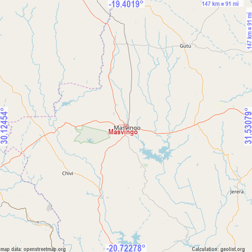
Masvingo GPS coordinates[2]
20° 3' 49.428" South, 30° 49' 39.576" East
| Map corner | latitude | longitude |
|---|---|---|
| Upper-left | -19.4019°, | 30.12454° |
| Center: | -20.06373°, | 30.82766° |
| Lower-right: | -20.72278°, | 31.53079° |
| Map W x H: | 146.9×146.9 km | = 91.3×91.3mi |
| max Lat: | -16.03333° ⇑86.2% North |
| Masvingo: | -20.06373° |
| min Lat: | ⇓13.8% South -22.21667° |
| min Long | Masvingo | max Long |
| 25.83066° | 30.82766° | 32.86667° |
| W 53.8%⇐ | ⇒46.2% E |
Elevation
Elevation of Masvingo is 1091 m = 3579 ft, and this is 106.7 m = 350 ft below average elevation for this country.
| Max E: |
1706 m = 5597 ft | 72.3% |
| Avg. | 1197.7 m = 3929 ft | |
| Masvingo | 1091 m = 3579 ft | |
Min E: |
402 m = 1319 ft | 27.7% |
See also: Masvingo elevation on elevation.city.
Geographical zone
Masvingo is located in South Torrid zone (between Equator and Tropic of Capricorn). Distance of this Southern Tropic circle is 375 km =233 mi to South.| Distance of | km | miles | from Masvingo |
|---|---|---|---|
| Equator | 2230.9 | 1386.2 | to North |
| Tropic Capricorn | 375 | 233 | to South |
| Antarctic Circle | 5170.3 | 3212.7 | to South |
| South Pole | 7776.2 | 4831.9 | to South |


Nearby cities:
15 places around Masvingo: (largest is in red/bold)
• Chipinge
188 km =116.8 mi,  94°
94°
• Chiredzi
140.2 km =87.1 mi,  141°
141°
• Chivhu
116.1 km =72.1 mi,  3°
3°
• Dorowa Mining Lease
147.1 km =91.4 mi,  41°
41°
• Filabusi
169.1 km =105.1 mi,  252°
252°
• Gweru
125.9 km =78.2 mi,  302°
302°
• Insiza
173 km =107.5 mi,  280°
280°
• Kwekwe
165 km =102.5 mi,  319°
319°
• Lalapanzi
106 km =65.9 mi, 320°
• Mashava
36.2 km =22.5 mi,  274°
274°
• Mvuma
92.7 km =57.6 mi,  340°
340°
• Redcliff
158.4 km =98.4 mi, 316°
• Shangani
155.9 km =96.9 mi, 281°
• Shurugwi
96.4 km =59.9 mi, 296°
• Zvishavane
84.6 km =52.6 mi, 249°
Sources, notices
• [Note1] Compared only with cities in Zimbabwe existing in our database
• [Src1] Map data: © OpenStreetMap contributors (CC-BY-SA)
• [Src2] Other city data from geonames.org with taken over terms of usage.
• [Src3] Geographical zone / Annual Mean Temperature by Robert A. Rohde @ Wikipedia
