Inyati geodata
Inyati (Matabeleland North) is a populated place; located in Zimbabwe in Africa/Harare (GMT+2) time zone. With population of 8,402 people, there are 36 cities with bigger population in this country. Compared to other cities in Zimbabwe, 78.5% of cities are located further ↑North; 86.2% of cities are located further →East and 64.6% of cities have lower elevation than Inyati. Note1


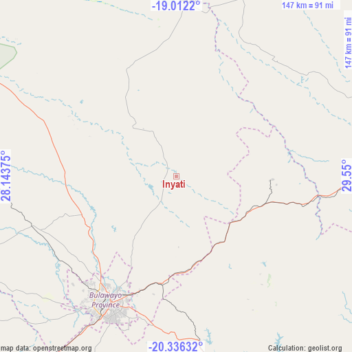
Inyati GPS coordinates[2]
19° 40' 32.268" South, 28° 50' 48.732" East
| Map corner | latitude | longitude |
|---|---|---|
| Upper-left | -19.0122°, | 28.14375° |
| Center: | -19.67563°, | 28.84687° |
| Lower-right: | -20.33632°, | 29.55° |
| Map W x H: | 147.2×147.2 km | = 91.5×91.5mi |
| max Lat: | -16.03333° ⇑78.5% North |
| Inyati: | -19.67563° |
| min Lat: | ⇓21.5% South -22.21667° |
| min Long | Inyati | max Long |
| 25.83066° | 28.84687° | 32.86667° |
| W 13.8%⇐ | ⇒86.2% E |
Elevation
Elevation of Inyati is 1333 m = 4373 ft, and this is 135.3 m = 444 ft above average elevation for this country.
| Max E: |
1706 m = 5597 ft | 35.4% |
| Inyati | 1333 m 4373 ft | |
| Avg. | 1197.7 m = 3929 ft | |
Min E: |
402 m = 1319 ft | 64.6% |
See also: Zimbabwe elevation on elevation.city.
Geographical zone
Inyati is located in South Torrid zone (between Equator and Tropic of Capricorn). Distance of this Southern Tropic circle is 418.2 km =259.9 mi to South.| Distance of | km | miles | from Inyati |
|---|---|---|---|
| Equator | 2187.7 | 1359.4 | to North |
| Tropic Capricorn | 418.2 | 259.9 | to South |
| Antarctic Circle | 5213.4 | 3239.5 | to South |
| South Pole | 7819.3 | 4858.7 | to South |


Nearby cities:
15 places around Inyati: (largest is in red/bold)
• Bulawayo
59.5 km =37 mi,  207°
207°
• Esigodini
68.7 km =42.7 mi,  173°
173°
• Filabusi
105.8 km =65.7 mi,  154°
154°
• Gokwe
163.8 km =101.8 mi,  3°
3°
• Gwanda
141.2 km =87.7 mi, 173°
• Gweru
104.7 km =65.1 mi,  76°
76°
• Insiza
38.9 km =24.2 mi,  107°
107°
• Kwekwe
131.3 km =81.6 mi,  50°
50°
• Lalapanzi
144.6 km =89.9 mi,  74°
74°
• Lupane
136.9 km =85.1 mi,  307°
307°
• Plumtree
140.1 km =87.1 mi,  230°
230°
• Redcliff
121.5 km =75.5 mi, 53°
• Shangani
55.7 km =34.6 mi,  102°
102°
• Shurugwi
121.4 km =75.4 mi,  89°
89°
• Zvishavane
146.6 km =91.1 mi,  119°
119°
Sources, notices
• [Note1] Compared only with cities in Zimbabwe existing in our database
• [Src1] Map data: © OpenStreetMap contributors (CC-BY-SA)
• [Src2] Other city data from geonames.org with taken over terms of usage.
• [Src3] Geographical zone / Annual Mean Temperature by Robert A. Rohde @ Wikipedia
