Mashava geodata
Mashava (Masvingo) is a populated place; located in Zimbabwe in Africa/Harare (GMT+2) time zone. With population of 12,994 people, there are 28 cities with bigger population in this country. Compared to other cities in Zimbabwe, 84.6% of cities are located further ↑North; 50.8% of cities are located further →East and 76.9% of cities have higher elevation than Mashava. Note1


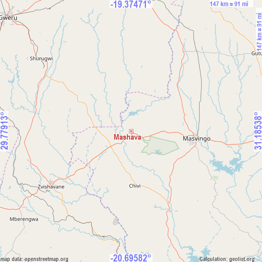
Mashava GPS coordinates[2]
20° 2' 11.94" South, 30° 28' 56.1" East
| Map corner | latitude | longitude |
|---|---|---|
| Upper-left | -19.37471°, | 29.77913° |
| Center: | -20.03665°, | 30.48225° |
| Lower-right: | -20.69582°, | 31.18538° |
| Map W x H: | 146.9×146.9 km | = 91.3×91.3mi |
| max Lat: | -16.03333° ⇑84.6% North |
| Mashava: | -20.03665° |
| min Lat: | ⇓15.4% South -22.21667° |
| min Long | Mashava | max Long |
| 25.83066° | 30.48225° | 32.86667° |
| W 49.2%⇐ | ⇒50.8% E |
Elevation
Elevation of Mashava is 1046 m = 3432 ft, and this is 151.7 m = 498 ft below average elevation for this country.
| Max E: |
1706 m = 5597 ft | 76.9% |
| Avg. | 1197.7 m = 3929 ft | |
| Mashava | 1046 m = 3432 ft | |
Min E: |
402 m = 1319 ft | 23.1% |
See also: Zimbabwe elevation on elevation.city.
Geographical zone
Mashava is located in South Torrid zone (between Equator and Tropic of Capricorn). Distance of this Southern Tropic circle is 378.1 km =234.9 mi to South.| Distance of | km | miles | from Mashava |
|---|---|---|---|
| Equator | 2227.9 | 1384.4 | to North |
| Tropic Capricorn | 378.1 | 234.9 | to South |
| Antarctic Circle | 5173.3 | 3214.5 | to South |
| South Pole | 7779.2 | 4833.8 | to South |


Nearby cities:
15 places around Mashava: (largest is in red/bold)
• Chiredzi
167 km =103.8 mi,  132°
132°
• Chivhu
120.8 km =75.1 mi,  20°
20°
• Dorowa Mining Lease
171.1 km =106.3 mi,  50°
50°
• Esigodini
165.2 km =102.7 mi,  260°
260°
• Filabusi
136.5 km =84.8 mi,  246°
246°
• Gweru
95.4 km =59.3 mi,  313°
313°
• Insiza
137 km =85.1 mi,  281°
281°
• Kwekwe
141.7 km =88 mi,  330°
330°
• Lalapanzi
84.6 km =52.6 mi,  337°
337°
• Masvingo
36.2 km =22.5 mi,  94°
94°
• Mvuma
84.4 km =52.4 mi,  3°
3°
• Redcliff
133.5 km =83 mi, 326°
• Shangani
120 km =74.6 mi, 283°
• Shurugwi
64.4 km =40 mi, 309°
• Zvishavane
54.1 km =33.6 mi,  233°
233°
Sources, notices
• [Note1] Compared only with cities in Zimbabwe existing in our database
• [Src1] Map data: © OpenStreetMap contributors (CC-BY-SA)
• [Src2] Other city data from geonames.org with taken over terms of usage.
• [Src3] Geographical zone / Annual Mean Temperature by Robert A. Rohde @ Wikipedia
