Shurugwi geodata
Shurugwi (Midlands) is a populated place; located in Zimbabwe in Africa/Harare (GMT+2) time zone. With population of 17,075 people, there are 26 cities with bigger population in this country. Compared to other cities in Zimbabwe, 76.9% of cities are located further ↑North; 63.1% of cities are located further →East and 84.6% of cities have lower elevation than Shurugwi. Note1


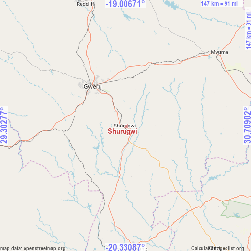
Shurugwi GPS coordinates[2]
19° 40' 12.576" South, 30° 0' 21.204" East
| Map corner | latitude | longitude |
|---|---|---|
| Upper-left | -19.00671°, | 29.30277° |
| Center: | -19.67016°, | 30.00589° |
| Lower-right: | -20.33087°, | 30.70902° |
| Map W x H: | 147.2×147.2 km | = 91.5×91.5mi |
| max Lat: | -16.03333° ⇑76.9% North |
| Shurugwi: | -19.67016° |
| min Lat: | ⇓23.1% South -22.21667° |
| min Long | Shurugwi | max Long |
| 25.83066° | 30.00589° | 32.86667° |
| W 36.9%⇐ | ⇒63.1% E |
Elevation
Elevation of Shurugwi is 1483 m = 4865 ft, and this is 285.3 m = 936 ft above average elevation for this country.
| Max E: |
1706 m = 5597 ft | 15.4% |
| Shurugwi | 1483 m 4865 ft | |
| Avg. | 1197.7 m = 3929 ft | |
Min E: |
402 m = 1319 ft | 84.6% |
See also: Zimbabwe elevation on elevation.city.
Geographical zone
Shurugwi is located in South Torrid zone (between Equator and Tropic of Capricorn). Distance of this Southern Tropic circle is 418.8 km =260.2 mi to South.| Distance of | km | miles | from Shurugwi |
|---|---|---|---|
| Equator | 2187.1 | 1359 | to North |
| Tropic Capricorn | 418.8 | 260.2 | to South |
| Antarctic Circle | 5214.1 | 3239.9 | to South |
| South Pole | 7819.9 | 4859.1 | to South |


Nearby cities:
15 places around Shurugwi: (largest is in red/bold)
• Chivhu
117.7 km =73.1 mi,  52°
52°
• Esigodini
132.5 km =82.3 mi,  238°
238°
• Filabusi
122 km =75.8 mi,  218°
218°
• Gweru
31.5 km =19.6 mi,  320°
320°
• Insiza
85.3 km =53 mi,  261°
261°
• Inyati
121.4 km =75.4 mi,  269°
269°
• Kadoma
149 km =92.6 mi,  356°
356°
• Kwekwe
84.9 km =52.8 mi,  346°
346°
• Lalapanzi
41.7 km =25.9 mi,  25°
25°
• Mashava
64.4 km =40 mi,  129°
129°
• Masvingo
96.4 km =59.9 mi,  116°
116°
• Mvuma
69.9 km =43.4 mi, 51°
• Redcliff
74.6 km =46.4 mi,  341°
341°
• Shangani
68.1 km =42.3 mi, 259°
• Zvishavane
73.3 km =45.5 mi,  175°
175°
Sources, notices
• [Note1] Compared only with cities in Zimbabwe existing in our database
• [Src1] Map data: © OpenStreetMap contributors (CC-BY-SA)
• [Src2] Other city data from geonames.org with taken over terms of usage.
• [Src3] Geographical zone / Annual Mean Temperature by Robert A. Rohde @ Wikipedia
