Gwanda geodata
Gwanda (Matabeleland South) is a seat of a first-order administrative division; located in Zimbabwe in Africa/Harare (GMT+2) time zone. With population of 14,450 people, there are 27 cities with bigger population in this country. Compared to other cities in Zimbabwe, 96.9% of cities are located further ↑North; 80% of cities are located further →East and 83.1% of cities have higher elevation than Gwanda. Note1


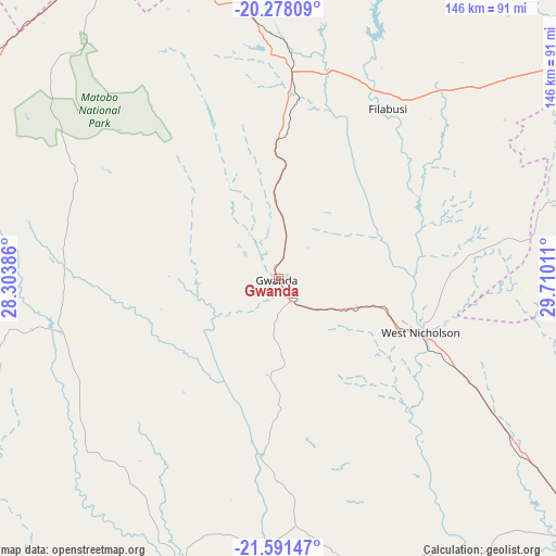
Gwanda GPS coordinates[2]
20° 56' 10.392" South, 29° 0' 25.128" East
| Map corner | latitude | longitude |
|---|---|---|
| Upper-left | -20.27809°, | 28.30386° |
| Center: | -20.93622°, | 29.00698° |
| Lower-right: | -21.59147°, | 29.71011° |
| Map W x H: | 146×146 km | = 90.7×90.7mi |
| max Lat: | -16.03333° ⇑96.9% North |
| Gwanda: | -20.93622° |
| min Lat: | ⇓3.1% South -22.21667° |
| min Long | Gwanda | max Long |
| 25.83066° | 29.00698° | 32.86667° |
| W 20%⇐ | ⇒80% E |
Elevation
Elevation of Gwanda is 966 m = 3169 ft, and this is 231.7 m = 760 ft below average elevation for this country.
| Max E: |
1706 m = 5597 ft | 83.1% |
| Avg. | 1197.7 m = 3929 ft | |
| Gwanda | 966 m = 3169 ft | |
Min E: |
402 m = 1319 ft | 16.9% |
See also: Zimbabwe elevation on elevation.city.
Geographical zone
Gwanda is located in South Torrid zone (between Equator and Tropic of Capricorn). Distance of this Southern Tropic circle is 278 km =172.7 mi to South.| Distance of | km | miles | from Gwanda |
|---|---|---|---|
| Equator | 2327.9 | 1446.5 | to North |
| Tropic Capricorn | 278 | 172.7 | to South |
| Antarctic Circle | 5073.3 | 3152.4 | to South |
| South Pole | 7679.2 | 4771.6 | to South |


Nearby cities:
15 places around Gwanda: (largest is in red/bold)
• Beitbridge
175.5 km =109.1 mi,  144°
144°
• Bulawayo
97.9 km =60.8 mi,  333°
333°
• Esigodini
72.4 km =45 mi,  353°
353°
• Filabusi
53.3 km =33.1 mi,  32°
32°
• Gweru
185.6 km =115.3 mi, 27°
• Insiza
129.8 km =80.7 mi,  8°
8°
• Inyati
141.2 km =87.7 mi, 353°
• Lalapanzi
216.2 km =134.3 mi, 34°
• Mashava
183.3 km =113.9 mi,  56°
56°
• Masvingo
213 km =132.4 mi, 62°
• Plumtree
133.6 km =83 mi,  292°
292°
• Redcliff
226.6 km =140.8 mi,  20°
20°
• Shangani
133.6 km =83 mi, 16°
• Shurugwi
175.1 km =108.8 mi,  36°
36°
• Zvishavane
129.4 km =80.4 mi, 58°
Sources, notices
• [Note1] Compared only with cities in Zimbabwe existing in our database
• [Src1] Map data: © OpenStreetMap contributors (CC-BY-SA)
• [Src2] Other city data from geonames.org with taken over terms of usage.
• [Src3] Geographical zone / Annual Mean Temperature by Robert A. Rohde @ Wikipedia
