Lalapanzi geodata
Lalapanzi (Midlands) is a populated place; located in Zimbabwe in Africa/Harare (GMT+2) time zone. With population of 1,390 people, there are 63 cities with bigger population in this country. Compared to other cities in Zimbabwe, 73.8% of cities are located further ↑North; 56.9% of cities are located further →East and 89.2% of cities have lower elevation than Lalapanzi. Note1


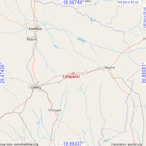
Lalapanzi GPS coordinates[2]
19° 19' 56.1" South, 30° 10' 39.648" East
| Map corner | latitude | longitude |
|---|---|---|
| Upper-left | -18.66744°, | 29.47456° |
| Center: | -19.33225°, | 30.17768° |
| Lower-right: | -19.99437°, | 30.88081° |
| Map W x H: | 147.5×147.5 km | = 91.7×91.7mi |
| max Lat: | -16.03333° ⇑73.8% North |
| Lalapanzi: | -19.33225° |
| min Lat: | ⇓26.2% South -22.21667° |
| min Long | Lalapanzi | max Long |
| 25.83066° | 30.17768° | 32.86667° |
| W 43.1%⇐ | ⇒56.9% E |
Elevation
Elevation of Lalapanzi is 1500 m = 4921 ft, and this is 302.3 m = 992 ft above average elevation for this country.
| Max E: |
1706 m = 5597 ft | 10.8% |
| Lalapanzi | 1500 m 4921 ft | |
| Avg. | 1197.7 m = 3929 ft | |
Min E: |
402 m = 1319 ft | 89.2% |
See also: Zimbabwe elevation on elevation.city.
Geographical zone
Lalapanzi is located in South Torrid zone (between Equator and Tropic of Capricorn). Distance of this Southern Tropic circle is 456.4 km =283.6 mi to South.| Distance of | km | miles | from Lalapanzi |
|---|---|---|---|
| Equator | 2149.5 | 1335.6 | to North |
| Tropic Capricorn | 456.4 | 283.6 | to South |
| Antarctic Circle | 5251.6 | 3263.2 | to South |
| South Pole | 7857.5 | 4882.4 | to South |


Nearby cities:
15 places around Lalapanzi: (largest is in red/bold)
• Beatrice
139.2 km =86.5 mi,  30°
30°
• Chakari
144.3 km =89.7 mi,  347°
347°
• Chegutu
133.7 km =83.1 mi,  358°
358°
• Chivhu
82.6 km =51.3 mi,  65°
65°
• Gweru
40.1 km =24.9 mi,  250°
250°
• Insiza
114.1 km =70.9 mi,  243°
243°
• Kadoma
114.5 km =71.1 mi, 346°
• Kwekwe
58.9 km =36.6 mi,  319°
319°
• Mashava
84.6 km =52.6 mi,  157°
157°
• Masvingo
106 km =65.9 mi,  140°
140°
• Mvuma
37.3 km =23.2 mi,  80°
80°
• Redcliff
53.1 km =33 mi,  308°
308°
• Shangani
98.7 km =61.3 mi, 239°
• Shurugwi
41.7 km =25.9 mi,  205°
205°
• Zvishavane
111.2 km =69.1 mi,  186°
186°
Sources, notices
• [Note1] Compared only with cities in Zimbabwe existing in our database
• [Src1] Map data: © OpenStreetMap contributors (CC-BY-SA)
• [Src2] Other city data from geonames.org with taken over terms of usage.
• [Src3] Geographical zone / Annual Mean Temperature by Robert A. Rohde @ Wikipedia
