Gokwe geodata
Gokwe (Midlands) is a populated place; located in Zimbabwe in Africa/Harare (GMT+2) time zone. With population of 18,942 people, there are 24 cities with bigger population in this country. Compared to other cities in Zimbabwe, 55.4% of cities are located further ↓South; 81.5% of cities are located further →East and 52.3% of cities have lower elevation than Gokwe. Note1


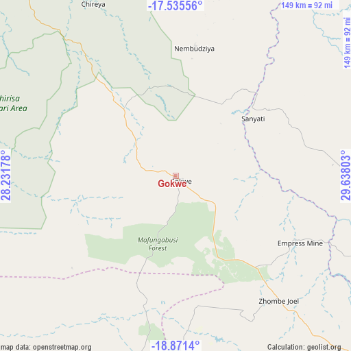
Gokwe GPS coordinates[2]
18° 12' 17.136" South, 28° 56' 5.64" East
| Map corner | latitude | longitude |
|---|---|---|
| Upper-left | -17.53556°, | 28.23178° |
| Center: | -18.20476°, | 28.9349° |
| Lower-right: | -18.8714°, | 29.63803° |
| Map W x H: | 148.5×148.5 km | = 92.3×92.3mi |
| max Lat: | -16.03333° ⇑44.6% North |
| Gokwe: | -18.20476° |
| min Lat: | ⇓55.4% South -22.21667° |
| min Long | Gokwe | max Long |
| 25.83066° | 28.9349° | 32.86667° |
| W 18.5%⇐ | ⇒81.5% E |
Elevation
Elevation of Gokwe is 1237 m = 4058 ft, and this is 39.3 m = 129 ft above average elevation for this country.
| Max E: |
1706 m = 5597 ft | 47.7% |
| Gokwe | 1237 m 4058 ft | |
| Avg. | 1197.7 m = 3929 ft | |
Min E: |
402 m = 1319 ft | 52.3% |
See also: Zimbabwe elevation on elevation.city.
Geographical zone
Gokwe is located in South Torrid zone (between Equator and Tropic of Capricorn). Distance of this Southern Tropic circle is 581.7 km =361.5 mi to South.| Distance of | km | miles | from Gokwe |
|---|---|---|---|
| Equator | 2024.2 | 1257.8 | to North |
| Tropic Capricorn | 581.7 | 361.5 | to South |
| Antarctic Circle | 5377 | 3341.1 | to South |
| South Pole | 7982.9 | 4960.3 | to South |


Nearby cities:
15 places around Gokwe: (largest is in red/bold)
• Banket
180 km =111.8 mi,  59°
59°
• Binga
180.7 km =112.3 mi,  291°
291°
• Chakari
102.4 km =63.6 mi,  81°
81°
• Chegutu
127.7 km =79.3 mi,  86°
86°
• Chinhoyi
163.2 km =101.4 mi, 55°
• Gweru
166.7 km =103.6 mi,  146°
146°
• Insiza
177.7 km =110.4 mi,  170°
170°
• Inyati
163.8 km =101.8 mi,  183°
183°
• Kadoma
104.5 km =64.9 mi,  97°
97°
• Karoi
174.7 km =108.6 mi,  27°
27°
• Kwekwe
122.8 km =76.3 mi,  130°
130°
• Lalapanzi
181.2 km =112.6 mi, 133°
• Lupane
143.7 km =89.3 mi,  235°
235°
• Redcliff
128.4 km =79.8 mi,  135°
135°
• Shangani
181.3 km =112.7 mi, 165°
Sources, notices
• [Note1] Compared only with cities in Zimbabwe existing in our database
• [Src1] Map data: © OpenStreetMap contributors (CC-BY-SA)
• [Src2] Other city data from geonames.org with taken over terms of usage.
• [Src3] Geographical zone / Annual Mean Temperature by Robert A. Rohde @ Wikipedia
